Affiliates
CalCOFI Partners
 |
Scripps Institution of Oceanography, Integrative Oceanography Division (IOD) Scripps Institution of Oceanography is one of the oldest, largest, and most important centers for ocean and earth science research, education, and public service in the world. Research at Scripps Institution of Oceanography encompasses physical, chemical, biological, geological, and geophysical studies of the oceans and earth. |
 |
NOAA Southwest Fisheries Science Center The National Marine Fisheries Service (NMFS) contributes to the CalCOFI partnership in three major areas: 1) CalCOFI sea surveys, 2) scientific research on the fisheries, ecology, and oceanography of the California Current system, and 3) communication of the results of the CalCOFI surveys and related laboratory research to the scientific community, the Pacific Fisheries Management Council. |
 |
California Department of Fish & Wildlife, Marine Region OUR MISSION: "To protect, maintain, enhance, and restore California's marine ecosystems for their ecological values and their use and enjoyment by the public through good science and effective communication." The Marine Region is responsible for protecting and managing California's marine resources under the authority of laws and regulations created by the State Legislature, the Fish and Game Commission, and the Pacific Fishery Management Council. The Marine Region was established in November 1997, as an outgrowth of planning actions taken by the Department of Fish and Wildlife in the mid-1990s to increase its effectiveness. A task force, which convened in 1997, developed recommendations for the establishment of a new Marine Region. |
|
|
LTER California Current Ecosystem The California Current System is a coastal upwelling biome, as found along the eastern margins of all major ocean basins. These are among the most productive ecosystems in the world ocean. The California Current Ecosystem LTER (32.9°, -120.3°) is investigating nonlinear transitions in the California Current coastal pelagic ecosystem, with particular attention to long-term forcing by a secular warming trend, the Pacific Decadal Oscillation, and El Niño in altering the structure and dynamics of the pelagic ecosystem. The California Current sustains active fisheries for a variety of finfish and marine invertebrates, modulates weather patterns and the hydrologic cycle of much of the western United States, and plays a vital role in the economy of myriad coastal communities. |
CalCOFI Affiliates
|
|
Scripps Whale Acoustics Lab Since April 2004, the Scripps Whale Acoustics Lab at Scripps Institution of Oceanography added a visual and acoustic marine mammal survey component to the CalCOFI project to study cetacean ecology and habitat. Visual monitoring is conducted during quarterly cruises by Cascadia Research personnel using handheld 7x binoculars. Supplementary Bigeyes (25x magnification) are used for species identification when necessary. Visual monitoring provides excellent data for highly visible species in calm to moderate weather. Concurrently, acoustic technicians survey with a towed hydrophone array during the transit between CalCOFI stations and with sonobuoys while on station, allowing collection of distribution data on vocal animals that may have been missed visually due to darkness, rough weather, distance from transect line, being underwater, or other reasons. Additionally, long-term acoustic monitoring is conducted at seven CalCOFI stations using bottom-mounted, High-frequency Acoustic Recording Packages (HARPs). These data will provide information on the annual and seasonal presence of cetaceans, and may be used to evaluate daily patterns of vocalization behavior. By integrating CalCOFI environmental and cetacean data, we plan to develop ecological models for cetacean habitat in the region offshore of southern California and to improve our understanding of their role in the California Current ecosystem. |
 |
Farallon Institute The Farallon Institute for Advanced Ecosystem Research is a nonprofit scientific organization dedicated to the understanding and preservation of healthy marine ecosystems. Farallon Institute sponsors the bird observers program for CalCOFI and related cruises. |
|
|
SCCOOS: Southern California Coastal Ocean Observing System SCCOOS brings together coastal observations in the Southern California Bight to provide information necessary to address issues in climate change, ecosystem preservation and management, coastal water quality, maritime operations, coastal hazards and national security. |
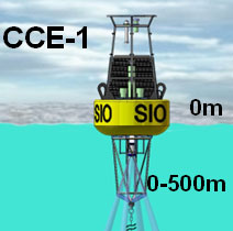 |
CCE Moorings The current (fifth) CCE-1 mooring was deployed on March 06, 2011 with the R/V New Horizon. Real-time data can be viewed in the data section, and the sensor layout is shown in the diagram on the CCE-1 web page. The surface buoy is equipped with a meteorological sensor package providing air pressure, temperature, and wind speed, furthermore a CO2 system that measures CO2 concentration of the atmosphere and the surface water, and sensors for water temperature, salinity, oxygen concentration, and an acoustic doppler current profiler for water currents in the upper 500m. The first CCE-2 mooring was deployed at the location of CalCOFI station 80.55 in January 2010. This deployment was accelerated in order to measure the effects of the present El Niño conditions in the nearshore upwelling zone off Pt. Conception, in comparison with El Niño effects in the offshore California Current location of CCE-1 |
|
|
ICESS SVP Drifter Project Pacific Gyre GPS/ Mobitex™ Microstar drifters are deployed to observe and study near-shore ocean circulation off the Southern California coast. The drifters record their position with GPS every 10 minutes and transmit their position data in near real-time to a web-based host computer using the Mobitex narrow band, data-only, cellular communications system. This sort of time and space resolution enables characteristic near-shore circulation patterns to be properly resolved. The drifters give direct observations of paths taken by freely floating objects at the ocean surface such as spilled oil, other pollutants, or things lost at sea. real-time drifter data from CalCOFI deployments. |
 |
MBARI SECRET: Studies of Ecological and Chemical Responses to Environmental Trends Quarterly observations on CalCOFI Line 67. In 1997 MBARI expanded hydrographic observations into the California Current. Quarterly cruises (cruise list) were scheduled in 1997-2008 to survey the areas offshore of Monterey Bay (map). MBARI scientists collect samples for analysis of Salinity, Oxygen, TCO2 (DIC+DOC), Nutrients (Phosphate, Silicate, Nitrate, Nitrite, and Ammonium), Chlorophyll, C14 and N15 Primary Production, and surface Phytoplankton samples of A*, HPLC, POC, FCM, and Quanitative Phytoplankton (QP). From the underway surface water, pCO2 and fluorometeric samples are taken. These samples and the cruises they are collected on support the studies of physical, chemical and biological dynamics off the west coast of Central California and have resulted in a rich and consistent history of ocean dynamics, from seasonal variations to longterm trends, such as El Nino Southern Oscillation (ENSO) and the Pacifc Decadal Oscillation (PDO). Cycles which have direct effects on the coastal marine life and economy (M. Blum, MBARI). |
 |
IMECOCAL Investigaciones Mexicanas de la Corriente de California A program of ocean monitoring in the Southern Region of the California Current - off Baja California, Mexico - has been underway since autumn, 1997. It is modeled after the CalCOFI program, sampling stations off Baja California.
CUFES: Continuous Underway Fish Egg Sampler (http://cufes.ucsd.edu/)
MBARI scientists collect samples for analysis of Salinity, Oxygen, TCO2 (DIC+DOC), Nutrients (Phosphate, Silicate, Nitrate, Nitrite, and Ammonium), Chlorophyll, C14 and N15 Primary Production, and surface Phytoplankton samples of A*, HPLC, POC, FCM, and Quanitative Phytoplankton (QP). From the underway surface water, pCO2 and fluorometeric samples are taken. These samples and the cruises they are collected on support the studies of physical, chemical and biological dynamics off the west coast of Central California and have resulted in a rich and consistent history of ocean dynamics, from seasonal variations to longterm trends, such as El Nino Southern Oscillation (ENSO) and the Pacifc Decadal Oscillation (PDO). Cycles which have direct effects on the coastal marine life and economy. (M. Blum, MBARI) |


 The Continuous Underway Fish Egg Sampler (CUFES) is an instrument used to collect pelagic eggs of fish and related hydrographic data from ~3m depth on a moving ship. These samples and data, typically collected during winter and spring cruises, are used to investigate spawning habitat and estimate spawning biomass. When large aggregations of fish eggs are present, Pair-o-vet vertical net tows are done to calibrate egg density.

