 Date Created: 03 Jul 2018; Subsject to Revision
Platform: R/V Sally Ride
Project Number: CalCOFI 1810SR; UNOLS SR1815
Project Title: CalCOFI Autumn Survey.
Project Dates: 14 to 29 Oct 2018
Prepared by: Daniel Schuller, Chief Scientist, and James R Wilkinson, Integrative Oceanography Division, Scripps Institution of Oceanography
Dated: 16 Aug 2018
PDFs:
- Cruise Instructions
- Station Order & Coordinates;
- Chemical Inventory
- Station Activities
- Station Sampling
- Predicted Station Schedule
I. Overview
- Brief Summary and Project Period: Survey the distributions and abundances of pelagic fish stocks, their prey, and their biotic and abiotic environments in the area of the California Current between San Diego, California and Avila Beach, California during the period of 1 - Aug 16 2017.
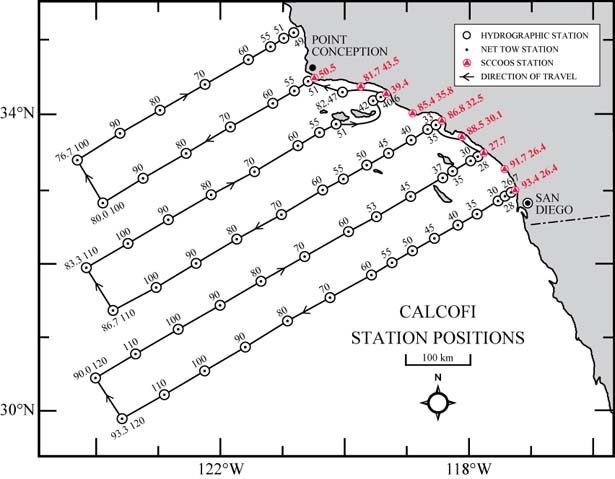
- Operating Area: From San Diego, CA to Avila Beach, CA and out 300 nautical miles. Please refer to Station Order & Coordinates PDF
-
Summary of Objectives: Survey the distributions and abundances of pelagic fish stocks, their prey, and their biotic and abiotic environments in the area of the California Current between San Diego, California and Avila Beach, California.
- I.C.1. Continuously sample sea-surface temperature, salinity, and chlorophyll-a using a thermosalinometer. These data will be used to estimate the physical oceanographic habitats for target species.
- I.C.2. Continuously sample air temperature, barometric pressure, and wind speed and direction using an integrated weather station.
- I.C.3. Sample profiles of seawater temperature, salinity, chlorophyll-a, nutrients, and phytoplankton using a CTD with water-sampling rosette and other instruments at prescribed stations. Measurements of extracted chlorophyll and phaeophytin will be obtained with a fluorometer. Primary production will be measured as C14 uptake in a six hour in situ incubation. Nutrients will be measured with an auto-analyzer. These data will be used to estimate primary productivity and the biotic and abiotic habitats for target species.
- I.C.4. Sample the light intensity in the photic zone using a standard secchi disk once per day in conjunction with a daytime CTD station. These data will be used to interpret the measurements of primary production.
- I.C.5. Sample plankton using a CalBOBL (CalCOFI Bongo Oblique) at prescribed stations. These data will be used to estimate the distributions and abundances of ichthyoplankton and zooplankton species.
- I.C.6. Sample plankton using a Manta (neuston) net at prescribed stations. These data will be used to estimate the distributions and abundances of ichthyoplankton species.
- I.C.7. Sample the vertically integrated abundance of fish eggs using a Pairovet net at prescribed stations. These data will be used to quantify the abundances and distributions of fish eggs.
- I.C.8. Sample plankton using a PRPOOS (Planktonic Rate Processes in Oligotrophic Ocean Systems net) at all prescribed CalCOFI stations on lines 90.0, 86.7, 83.3 and 80.0 only. These data will be used in analyses by the LTER (Long Term Ecological Research) project.
- I.C.9. Continuously observe, during daylight hours, seabirds and mammals. These data will be used to estimate the distributions and abundances of seabirds and marine mammals.
-
Participating Institutions
- I.D.1 Southwest Fisheries Science Center (SWFSC)
- I.D.2 Scripps Institution of Oceanography (SIO)
-
Administrative
-
Points of Contacts:
- Chief Scientist: Dan Schuller 858-822-0305, 9500 Gilman Dr, Dept 0206, La Jolla, CA, 92093 (This email address is being protected from spambots. You need JavaScript enabled to view it.)
- Alternate: Jennifer Rodgers-Wolgast 858-534-2888, 9500 Gilman Dr, Dept 0206, La Jolla, CA, 92093 (This email address is being protected from spambots. You need JavaScript enabled to view it.)
- Diplomatic Clearances: N/A
-
Licenses and Permits
- All marine mammal work is covered under a federal research permit NMFS Permit 727-1915 issued to Dr. John Hildebrand of SIO.
- CDFW ON April 2, 2015 to NOAA-SWFSC-FRD-Cisco Werner (SC- 12372)
-
Points of Contacts:
II. Operations
-
Project Itinerary
- Oct 11 2018 Load scientific gear on SIO RV Sally Ride at Nimitz Marine Facilities (MarFac), Pt Loma
- Oct 14 0700: All cruise participants onboard
- Oct 14 0800: Depart San Diego, CA
- Oct 29 1600: Arrive San Diego, CA
- Oct 30: 0800: Unload RV Sally Ride at MarFac
-
Staging and De-staging
- Staging for CalCOFI requires 2.5 days. Final de-staging will be conducted in San Diego, CA (MarFac).
- We request 2 laboratory vans to be craned onto the afterdeck and secured in San Diego prior to departure. The dimension of the van 1 is approximately 8x10x8 feet weighing 6500 lbs. Dimensions of GP van is approximately 8x20x8 feet weighing 8500 lbs. Power requirement is 110V.
- We request 1 Seamac electric winch to be craned onto the afterdeck and secured in San Diego prior to departure. The dimension of the winch is 4.5x4.5 feet. Power requirement is 440V 3-phase.
-
Operations to be conducted
-
II.B.1. Underway Operations
- II.B.1.a. Thermosalinometer sampling - The RV Sally Ride will provide and maintain a thermosalinometer (TSG), which is calibrated and in working order, for continuous measurement of surface water temperature and salinity.
- II.B.1.c. Acoustic hydrophone: During transit between most daylight stations, an acoustic hydrophone array will be towed from the stern at a distance of 300 meters with a deck loaded winch to record sounds from marine mammals. The winch is 440V 3-phase with a deck pattern of 4.5 by 4.5 feet. Upon approaching a station, two sonobuoys will be deployed one nautical mile prior to stopping for station work.
- II.B.1.d. Visual Observations: Two or more marine mammal observers will occupy the forward observation deck during daylight hours while the ship transits between stations. At 2 miles from daylight station arrival, we request the bridge notify the observers so they can retrieve the hydrophone and prepare for station arrival. The hydrophone can be retrieved at ship’s full speed. At 1 mile prior to each daylight station marine mammal observers will deploy 2 sonobuoys.
- II.B.1.e. Wave buoy deployments as vessel steams away from station. 4 total for cruise deployed by research technician and/or science party.
-
II.B.2. Station Operations: each standard station will include the following:
- II.B.2.a. CTD/Rosette consisting of 24 10-liter hydrographic bottles will be lowered to approximately 515 meters (depth permitting) at each station to measure physical parameters and collect water at discrete depths for analysis of: salinity, nutrients, oxygen, chlorophyll, etc. It is requested that the hydraulic hoist on the port side trolley way be installed and operational.
- II.B.2.b. CalBOBL (CalCOFI Bongo Oblique): standard oblique plankton tow with 300 meters of wire out, depth permitting, using paired 505 µm mesh nets with 71 cm diameter openings. The technical requirements for this tow are: Descent wire rate of 50 meters per minute and an ascent wire rate of 20 meters per minute. All tows with ascending wire angles lower than 38° or higher than 51° in the final 100 meters of wire will be repeated. Additionally, a 45° wire angle should be closely maintained during the ascent and descent of the net frame. The port side sample will be preserved in buffered ethanol at every station.
- II.B.2.c. Manta net (neuston) tow: using a 505 µm mesh net on a frame with a mouth area of 0.1333 m². Tows are 15 minutes in duration at towing speed of approximately 1.5 - 2.0 knots. Wire angles should be kept between 15° and 25°.
- II.B.2.d. Pairovet net: will be fished from 70 meters to the surface (depth permitting) using paired 25 cm diameter 150 µm mesh nets at all stations out to and including station 70.0. The technical requirements for Pairovet tows are: Descent rate of 70 meters per minute, a terminal depth time of 10 seconds and an ascent rate of 70 meters per minute. All tows with wire angles exceeding 15° during the ascent will be repeated.
- II.B.2.e. A PRPOOS (Planktonic Rate Processes in Oligotrophic Ocean Systems) net will be taken on specific stations on line 90.0, 86.7, 83.3, and 80.0. These stations are occupied as part of the LTER (Long Term Ecological Research) project. The mesh of the PRPOOS net is 202 µm and the tow is a vertical cast up from 210 meters. The technical requirements for the PRPOOS tows are: Decent rate of 40 meters per minute, a terminal depth time of 20 seconds and an ascent rate of 50 meters per minute.
- II.B.2.f. Primary productivity: at about 1100 hours on each day a primary productivity CTD cast consisting of six 10-liter hydrographic bottles (mounted on CTD frame) will be carried out. The cast arrangement will be determined by a Secchi disc observation. This cast will be in conjunction with an already scheduled station. The purpose of the cast is to collect water from six discrete depths for daily in situ productivity experiments. Measurements of extracted chlorophyll and phaeophytin will be obtained with a fluorometer. Primary production will be measured as C14 uptake in a six hour in situ incubation. Nutrients will be measured with an auto-analyzer. All radioisotope work areas will be given a wipe test before the departure of the SIO technical staff.
- II.B.2.g. A light meter (Secchi disk) will be used to measure the light intensity in the euphotic zone once a day with the primary productivity cast and all daytime stations.
- II.B.2.h. Weather observations.
- II.B.2.i. Radiosonosde balloon deployments. Balloons to be deployed by scientific personnel at CTD stations.
-
II.B.3.a. Order of Operations for each standard station:
- CTD to 515 meters with 24 bottle rosette (depth premitting)
- Secchi disk on daylight satations - secchi may be before the CTD on daily primary productivity stations which is typically between 0900-1200.
- PRPOOS net tow (lines 90.0, 86.7, 83.3 and 80.0 only).
- Pairovet net tow (on all lines out to station 70.0 but not to include near shore SCCOOS).
- Manta net tow (on all stations except for near shore SCCOOS and stations after line 76.7).
- Bongo net tow (on all stations).
-
II.B.4.a.
- Vessel speeds are restricted on research cruises in part to reduce the risk of ship strikes with marine mammals. Transit speeds vary from 8-11 knots.
-
While underway:
- We will have a bird observer on the flying bridge during all daylight transects.
- We will have 2 marine mammal observers on the forward observation deck during all daylight transects.
-
We will have a marine mammal acoustician with a towed hydrophone. The hydrophone will be towed off the stern at a distance of 300 meters between daylight stations. The hydrophone will be deployed at a ship speed of 5 knots while leaving a station. Once deployed, ship can travel at full speed. The hydrophone can be retrieved at ship’s full speed.
At 2 mile from daylight station arrival, we request the bridge notify the marine mammal observers so they can prepare for station arrival and retrieve the hydrophone.
At 1 mile prior to each daylight station marine mammal observers will deploy 2 sonobuoys. The hydrophone will be retrieved at this time.
Communication will be open to bridge during all hydrophone deployments and retrievals.
-
Conditions which preclude normal operations:
- In the event of poor weather conditions, we will work with the ship’s officers on developing the best strategy for completion of all stations safely.
- We have replacement gear for most operations. Equipment failure should not impact our project.
- Prior to departure, the Chief Scientist will conduct a meeting of the scientific party to train them in sample collection and inform them of project objectives. Some vessel protocols, e.g., meals, watches, etiquette, etc. will be presented by the ship’s First Mate or Resident Technician.
-
II.B.1. Underway Operations