CRUISE INSTRUCTIONS (Complete pdf)
Ship: R/V Ocean Starr
Cruise Number: 1207-OS
Cruise Dates: July 2 – August 31, 2012
Cruise Title: California Current Ecosystem (CCE) Survey.
Study Area: US/Mexican border to San Francisco, with variable transect lengths.
Itinerary:
- Leg 1: 2 JUL San Diego 19 JUL – Arrive San Diego, CA 18 DAS
- Leg 2: 22 JUL San Diego 01 AUG - Arrive San Diego, CA 11 DAS
- Leg 3: 02 AUG San Diego 16 AUG – Arrive Port Hueneme, CA 15 DAS
- Leg 4: 17 AUG Port Hueneme 31 AUG – Arrive San Francisco, CA 16 DAS
Total 60 DAS
Sponsoring Institution:
- NOAA/NMFS, Southwest Fisheries Science Center (SWFSC)
- Fisheries Resources Division (FRD)
| CalCOFI-CCE 1207 Legs 1 & 2 | CCE Island Wake Survey Area Leg 2 | CalCOFI-CCE 1207 Legs 3 & 4 |
 |
 |
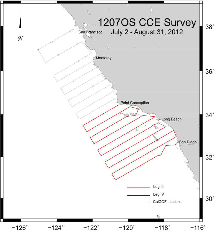 |
| Refer to the final Cruise Instruction pdf for details; click images for larger maps. | ||
Cruise Description and Objectives:
PLAN OF OPERATIONS
1.0 OPERATIONS
The Ocean Starr will conduct operations from south to north along the west coast from San Diego to San Francisco, CA. The April CCE Survey was conducted as a two ship synoptic survey of the western US coast of North America. The current July survey extends the survey into the summer season, repeating most of the April transect lines of the April survey, south of San Francisco, applying the same methodologies, but incorporating time to (1) retrieve and service two oceanographic moorings, and (2) to carry out some intensive sampling of island wakes near the Catalina and San Clemente Islands, and to the south of San Nicolas Island.
1.1.1 Standard CalCOFI station work will include the following:
1.1.3 Acoustics – Calibration of the Simrad EK-60 echosounder will be performed at the beginning of the cruise (requiring 6-12 hours). The EK-60 echosounder will be operated at 38, 70, 120 and 200 kHz and interfaced to a data acquisition system to estimate small pelagic and krill biomass between 10 and a maximum of 750 m. The vessel's EQ-50, ES-60 or Skipper depth sounder may be used minimally at the discretion of the Commanding Officer, but will normally remain off while underway. The ship shall inform the Cruise Leader of any use of the vessel's sounders, as it interferes with the signals received on the scientific EK-60 that will be used continuously.
1.1.4 CUFES - The egg pump will be mounted inside the ship’s hull drawing water from a depth of three meters. During the grid occupation, the pump will run continuously between stations to sample any pelagic fish eggs. Approximately 640 liters/minute is sent through a concentrator which filters all material larger than 505µm. The sieved material is then collected and identified. All fish eggs are identified to lowest taxa, counted and entered into the data acquisition software. Each sample entry is coupled with sea surface temperature, geographical position, wind speed and direction, date and time, and surface salinity. Sampling intervals will vary in length, depending on the number of fish eggs seen, from five to 30 minutes.
1.1.5 Surface trawling - During legs 3 - 4, a Nordic 264 surface trawl will be deployed between the hours of approximately 1800 and 0600 PST within the Southern California Bight and north up to San Francisco at positions determined by the acoustic data collected during daylight. The positions may be changed at the discretion of the Chief Scientist or Cruise Leader depending on information gained and occurrence of sardines, but without compromising the specified collection of plankton samples during the night on leg 3, and during day or night on leg 4. SWFSC Marine Mammal Protocols, as described below, will be followed prior to, during, and following any trawl deployment. During transit to each station, for a period of at least 30 minutes, the Captain, deckhands, and all available scientists will visually scan the sea surface for marine mammals and other protected species (e.g., dolphins, seals, sea-lions, and sea turtles). If marine mammals or other protected species are sighted during this period, or upon arrival at the station, the Cruise Leader, in consultation with the Captain and other knowledgeable members of the crew and scientific staff, will determine if trawling operations can commence without likelihood of interaction between the gear and the animals sighted. This determination will be based on the species and number of animals sighted, their behavior, their position, and their vector relative to the path of the vessel, the professional judgment of the SWFSC FPC, Cruise Leader, and Captain, and other factors. If marine mammals or turtles are observed during this period and are determined to be at appreciable risk of interaction with gear, then the vessel will move away from the animals, at least 0.5 nm, to a new location within the same general area. The visual scan for marine mammals and turtles will continue during each subsequent move until it is determined by the SWFSC FPC that trawling operations can safely commence, or until the station is abandoned. To reduce the potential of attracting marine mammals and other protected species to the vessel, trawl operations will be the first activity undertaken upon arrival at a new station. During each tow, the Captain and other designated individuals will keep a continuous watch for protected species. If animals are sighted while the net is in the water, the SWFSC FPC, in consultation with others, will determine the best strategy to avoid potential takes based on the species and number of animals sighted, their behavior, their positions, and vectors relative to the path of the vessel, and other factors. In some situations the decision may be to immediately retrieve the net and move away from the area. In other situations, the decision may be to continue towing until the animal(s) are clear of the area and away from potential contact with the gear during haulback, when the risk of entanglement is believed to be highest. Every effort will be made to deploy and retrieve the trawl net as quickly as possible (following all safety measures) to avoid possible interactions with marine mammals Recapping, a marine mammal watch will be initiated 30 minutes before trawling. Trawling will be the first activity on arrival at a trawling station, or will be located away from a previously occupied station to avoid any mammals that may have been attracted to the vessel. The trawl is fitted with a marine mammal excluding device (MMED) to avoid any take of cetaceans, pinnipeds, or turtles. If any protected species are detected, the trawl position will be moved to a new area and the protected-species watch reinitiated. If one or more marine mammals or sea turtles are inadvertently caught in the trawl net and brought aboard, it will be our highest priority to release the animal back into the water as soon as is safely possible. After release, the Chief Scientist will be responsible for recording the event in the data books, noting the status of the animal (e.g., healthy and alive, injured slightly, etc.), the species, and if possible other details such as sex and size. Any mammal capture will trigger immediate telephone contact to the SWFSC leadership, regardless of the time of day, who will take immediate action. Specifically, the SWFSC FPC will immediately notify Cisco Werner (858-334-3207; This email address is being protected from spambots. You need JavaScript enabled to view it.), Kristen Koch (858-546-7081; This email address is being protected from spambots. You need JavaScript enabled to view it.), or Russ Vetter (858-361-2361; This email address is being protected from spambots. You need JavaScript enabled to view it.), via telephone and convey all the pertinent information regarding the event, via email. Any alive, adult or juvenile salmon caught in the trawl will be immediately returned to the sea and assumed to have survived. Any incidentally killed will be frozen for genetic analyses. Each tow will be fished for 30 minutes in duration at a towing speed of approximately 3.5 knots. The catch of each tow will be processed in the following manner: The fish will be sorted to species, if possible, and the catch weighed. Sardines collected in each trawl will be randomly sub-sampled. Standard length and body weight will be measured, fish are sexed and maturity graded, otoliths will be collected, ovaries preserved in buffered formalin and tails preserved in ethanol vials for genetics. Standard length and body weight will also be measured for Northern anchovy, Jack and Pacific mackerels, hake and other species as time permits.
1.1.6 IKMT net sampling for juvenile fishes – During leg 2, an Isaacs-Kidd Mid-water Trawl (IKMT) will be deployed between the hours of approximately 1800 and 0600 PST at locations around Catalina and San Clemente Islands, and to the south of San Nicolas Island in the Southern California Bight at positions determined by prevailing oceanographic conditions just prior to the cruise. These conditions will be assessed based on the most recent available 1-km remote sensing imagery and line 90 spray glider data just prior to the cruise. The positions may be changed at the discretion of the Chief Scientist or Cruise Leader
1.1.7 Bird Observations – During daylight hours on legs 1 & 4, a bird observer will be posted on the flying bridge to identify and count birds while the ship is underway during cruise transects.
1.1.8 Acoustic hydrophone – During transit between most daylight stations on leg I (CalCOFI), an acoustic hydrophone array will be towed from the stern at a distance of 300 meters with a deck loaded winch to record sounds from marine mammals. The winch is 440V 3-phase with a deck pattern of 4.5 by 4.5 feet. Upon approaching a station, a sonobuoy will be deployed one nautical mile prior to stopping for station work.
1.1.9 Mooring operations – During the last three days of leg 2, the ship will occupy two locations (indicated in leg 2 of appendix 2) to service pre-existing and deploy new mooring arrays.
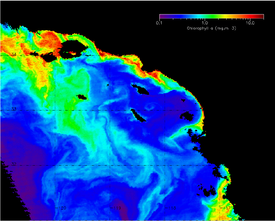
1.1.10 Island wakes survey (leg 2) – The effects of (1) currents flowing over variable topography and (2) winds on the ocean in the lee of the hills on islands creates different kinds of eddies due to currents, and to stratification of the water column due to shelter from prevailing winds. Current wakes increase mixing and enhance production, while wind wakes produce patches of warmer water. Both increased production and warmer water may be favorable to the growth and survival of larval and juvenile fishes. The purpose of the high resolution island wakes survey is to test the hypothesis that both wind and current wakes provide hotspots for the survival of larval and juvenile fishes. We predict that (1) density of larval and juvenile fishes will be higher in the wakes, (2) the size distributions of larval and juvenile fishes will be relatively larger in the wakes, and (3) that the condition of juvenile fishes will be higher in the wakes. Over the period of one week we will conduct high resolution CTD, CUFES, multi-frequency acoustic, plankton (bongo, pairovet, manta) and IKMT sampling on either side of, and within, current and wind wakes off Catalina and San Clemente Islands, and to the south of San Nicolas Island, as time permits. Exact sampling locations will be based on the best remote sensing and glider information prior to the cruise, as well as upon the predicted locations of the wind and current wakes based on previous studies in the literature. As a result, the survey design will be flexible and cannot be detailed in advance here. The general area of operations is shown in Figure 1, and a satellite image of the wakes is shown in Figure 1B.
Refer to the final Cruise Instructions pdf for additional information.
- To conduct continuous underway sampling of surface waters. Temperature and salinity will be automatically logged by computer with the output from the GPS navigational unit.
- To contribute to ongoing assessment of pelagic fish stocks between San Diego and San Francisco, California.
- To collect information the size distribution and species composition of pelagic fish for acoustics ground truth information using trawling.
- To monitor environmental conditions within the CCE survey area.
- To record continuous acoustic targets obtained with a multi-frequency Simrad EK-60 scientific sounder.
- To service and move three moorings on CalCOFI line 90.
- To carry out an intensive field survey of island wakes around San Clemente and Catalina Islands, and south of San Nicolas Island, to detect hotspots of production supporting juvenile sardine and other juvenile fish.
PLAN OF OPERATIONS
1.0 OPERATIONS
The Ocean Starr will conduct operations from south to north along the west coast from San Diego to San Francisco, CA. The April CCE Survey was conducted as a two ship synoptic survey of the western US coast of North America. The current July survey extends the survey into the summer season, repeating most of the April transect lines of the April survey, south of San Francisco, applying the same methodologies, but incorporating time to (1) retrieve and service two oceanographic moorings, and (2) to carry out some intensive sampling of island wakes near the Catalina and San Clemente Islands, and to the south of San Nicolas Island.
- During leg 1, the Ocean Starr will conduct standard CalCOFI operations on the basic six line/75 station grid.
- During leg 2, operations will focus on collaborative mooring operations with Scripps Institution of Oceanography and intensive sampling around Catalina and San Clemente Islands, and to the south of San Nicolas Island, as mentioned above.
- During leg 3, plankton stations will be limited to night hours to permit continuous acoustic running during daylight. Plankton sampling of this area, south of Point Conception, will recently have been done by the preceding CalCOFI survey. Each night time plankton station on leg 1 will comprise CTD, pairovet, bongo and manta tows at the same location.
- During leg 4, north of Point Conception, full station work will be carried out in daylight and at night.
1.1.1 Standard CalCOFI station work will include the following:
1.1.1.1 CTD/Rosette - consisting of 24 10-liter hydrographic bottles will be lowered to 500 meters (depth permitting) at each station to measure physical parameters and collect water at discrete depths for analysis of salinity.
1.1.1.2 CalBOBL (CalCOFI Bongo) - standard oblique plankton tow with 300 meters of wire out, depth permitting, using paired 505 µm mesh nets with 71 cm diameter openings. The technical requirements for this tow are: Descent wire rate of 50 meters per minute and an ascent wire rate of 20 meters per minute. All tows with ascending wire angles lower than 38° or higher than 51° in the final 100 meters of wire will be repeated. Additionally, a 45° wire angle should be closely maintained during the ascent and descent of the net frame. A self-contained LOPC (Laser Optical Particle Counter) will be mounted in the port side opening during each tow only during leg I (CalCOFI stations). The port side sample will be preserved in buffered ethanol at every station.
1.1.1.2 CalBOBL (CalCOFI Bongo) - standard oblique plankton tow with 300 meters of wire out, depth permitting, using paired 505 µm mesh nets with 71 cm diameter openings. The technical requirements for this tow are: Descent wire rate of 50 meters per minute and an ascent wire rate of 20 meters per minute. All tows with ascending wire angles lower than 38° or higher than 51° in the final 100 meters of wire will be repeated. Additionally, a 45° wire angle should be closely maintained during the ascent and descent of the net frame. A self-contained LOPC (Laser Optical Particle Counter) will be mounted in the port side opening during each tow only during leg I (CalCOFI stations). The port side sample will be preserved in buffered ethanol at every station.
1.1.1.3 Manta net (neuston) tow - using a 505 µm mesh net on a frame with a mouth area of 0.1333 m². Tows are 15 minutes in duration at a towing speed of approximately 1.5 - 2.0 knots. Wire angles should be kept between 15° and 25°.
1.1.1.4 Weather observations.
1.1.1.4 Weather observations.
1.1.1.5 Pairovet net - will be fished from 70 meters to the surface (depth permitting) using paired 25 cm diameter 150 µm mesh nets at all stations. The technical requirements for Pairovet tows are: Descent rate of 70 meters per minute, a terminal depth time of 10 seconds and an ascent rate of 70 meters per minute. All tows with wire angles exceeding 15° during the ascent will be repeated.
1.1.1.6 PRPOOS (leg 1 only): (Planktonic Rate Processes in Oligotrophic Ocean Systems net) will be fished from 210 meters to the surface(depth permitting) using a 50 cm diameter 202 µm mesh net. The PRPOOS will be towed at all prescribed CalCOFI stations on lines 90.0 and 80.0 as well as stations out to and including station 70.0 on lines 86.7 and 83.3. These data will be used in analyses by the LTER (Long Term Ecological Research) project. Descent rate of 40 meters per minute, a terminal depth time of 20 seconds and an ascent rate of 50 meters per minute. All tows with wire angles exceeding 15° during the ascent will be repeated.
1.1.1.6 PRPOOS (leg 1 only): (Planktonic Rate Processes in Oligotrophic Ocean Systems net) will be fished from 210 meters to the surface(depth permitting) using a 50 cm diameter 202 µm mesh net. The PRPOOS will be towed at all prescribed CalCOFI stations on lines 90.0 and 80.0 as well as stations out to and including station 70.0 on lines 86.7 and 83.3. These data will be used in analyses by the LTER (Long Term Ecological Research) project. Descent rate of 40 meters per minute, a terminal depth time of 20 seconds and an ascent rate of 50 meters per minute. All tows with wire angles exceeding 15° during the ascent will be repeated.
1.1.1.7 Primary productivity (leg 1 only): at about 1100 hours on each day of leg I a primary productivity CTD cast consisting of six 10-liter hydrographic bottles will be carried out. The cast arrangement will be determined by a Secchi disc observation. The purpose of the cast is to collect water from six discrete depths for daily in situ productivity experiments. Measurements of extracted chlorophyll and phaeophytin will be obtained with a fluorometer. Primary production will be measured as C14 uptake in a six hour in situ incubation. Nutrients will be measured with an auto-analyzer. All radioisotope work areas will be given a wipe test before the departure of the SIO technical staff.
1.1.1.8 A light meter will be used to measure the light intensity in the euphotic zone once a day with the primary productivity cast and all daytime stations.
1.1.2 Thermosalinometer sampling – SWFSC will provide a thermosalinometer (TSG), in calibrated and working order, for continuous measurement of surface water temperature and salinity. The Scientific Computing System (SCS) will serve as the main data collection system.. All SCS data will be provided to SWFSC personnel at the completion of the cruise.1.1.1.8 A light meter will be used to measure the light intensity in the euphotic zone once a day with the primary productivity cast and all daytime stations.
1.1.3 Acoustics – Calibration of the Simrad EK-60 echosounder will be performed at the beginning of the cruise (requiring 6-12 hours). The EK-60 echosounder will be operated at 38, 70, 120 and 200 kHz and interfaced to a data acquisition system to estimate small pelagic and krill biomass between 10 and a maximum of 750 m. The vessel's EQ-50, ES-60 or Skipper depth sounder may be used minimally at the discretion of the Commanding Officer, but will normally remain off while underway. The ship shall inform the Cruise Leader of any use of the vessel's sounders, as it interferes with the signals received on the scientific EK-60 that will be used continuously.
1.1.4 CUFES - The egg pump will be mounted inside the ship’s hull drawing water from a depth of three meters. During the grid occupation, the pump will run continuously between stations to sample any pelagic fish eggs. Approximately 640 liters/minute is sent through a concentrator which filters all material larger than 505µm. The sieved material is then collected and identified. All fish eggs are identified to lowest taxa, counted and entered into the data acquisition software. Each sample entry is coupled with sea surface temperature, geographical position, wind speed and direction, date and time, and surface salinity. Sampling intervals will vary in length, depending on the number of fish eggs seen, from five to 30 minutes.
1.1.5 Surface trawling - During legs 3 - 4, a Nordic 264 surface trawl will be deployed between the hours of approximately 1800 and 0600 PST within the Southern California Bight and north up to San Francisco at positions determined by the acoustic data collected during daylight. The positions may be changed at the discretion of the Chief Scientist or Cruise Leader depending on information gained and occurrence of sardines, but without compromising the specified collection of plankton samples during the night on leg 3, and during day or night on leg 4. SWFSC Marine Mammal Protocols, as described below, will be followed prior to, during, and following any trawl deployment. During transit to each station, for a period of at least 30 minutes, the Captain, deckhands, and all available scientists will visually scan the sea surface for marine mammals and other protected species (e.g., dolphins, seals, sea-lions, and sea turtles). If marine mammals or other protected species are sighted during this period, or upon arrival at the station, the Cruise Leader, in consultation with the Captain and other knowledgeable members of the crew and scientific staff, will determine if trawling operations can commence without likelihood of interaction between the gear and the animals sighted. This determination will be based on the species and number of animals sighted, their behavior, their position, and their vector relative to the path of the vessel, the professional judgment of the SWFSC FPC, Cruise Leader, and Captain, and other factors. If marine mammals or turtles are observed during this period and are determined to be at appreciable risk of interaction with gear, then the vessel will move away from the animals, at least 0.5 nm, to a new location within the same general area. The visual scan for marine mammals and turtles will continue during each subsequent move until it is determined by the SWFSC FPC that trawling operations can safely commence, or until the station is abandoned. To reduce the potential of attracting marine mammals and other protected species to the vessel, trawl operations will be the first activity undertaken upon arrival at a new station. During each tow, the Captain and other designated individuals will keep a continuous watch for protected species. If animals are sighted while the net is in the water, the SWFSC FPC, in consultation with others, will determine the best strategy to avoid potential takes based on the species and number of animals sighted, their behavior, their positions, and vectors relative to the path of the vessel, and other factors. In some situations the decision may be to immediately retrieve the net and move away from the area. In other situations, the decision may be to continue towing until the animal(s) are clear of the area and away from potential contact with the gear during haulback, when the risk of entanglement is believed to be highest. Every effort will be made to deploy and retrieve the trawl net as quickly as possible (following all safety measures) to avoid possible interactions with marine mammals Recapping, a marine mammal watch will be initiated 30 minutes before trawling. Trawling will be the first activity on arrival at a trawling station, or will be located away from a previously occupied station to avoid any mammals that may have been attracted to the vessel. The trawl is fitted with a marine mammal excluding device (MMED) to avoid any take of cetaceans, pinnipeds, or turtles. If any protected species are detected, the trawl position will be moved to a new area and the protected-species watch reinitiated. If one or more marine mammals or sea turtles are inadvertently caught in the trawl net and brought aboard, it will be our highest priority to release the animal back into the water as soon as is safely possible. After release, the Chief Scientist will be responsible for recording the event in the data books, noting the status of the animal (e.g., healthy and alive, injured slightly, etc.), the species, and if possible other details such as sex and size. Any mammal capture will trigger immediate telephone contact to the SWFSC leadership, regardless of the time of day, who will take immediate action. Specifically, the SWFSC FPC will immediately notify Cisco Werner (858-334-3207; This email address is being protected from spambots. You need JavaScript enabled to view it.), Kristen Koch (858-546-7081; This email address is being protected from spambots. You need JavaScript enabled to view it.), or Russ Vetter (858-361-2361; This email address is being protected from spambots. You need JavaScript enabled to view it.), via telephone and convey all the pertinent information regarding the event, via email. Any alive, adult or juvenile salmon caught in the trawl will be immediately returned to the sea and assumed to have survived. Any incidentally killed will be frozen for genetic analyses. Each tow will be fished for 30 minutes in duration at a towing speed of approximately 3.5 knots. The catch of each tow will be processed in the following manner: The fish will be sorted to species, if possible, and the catch weighed. Sardines collected in each trawl will be randomly sub-sampled. Standard length and body weight will be measured, fish are sexed and maturity graded, otoliths will be collected, ovaries preserved in buffered formalin and tails preserved in ethanol vials for genetics. Standard length and body weight will also be measured for Northern anchovy, Jack and Pacific mackerels, hake and other species as time permits.
1.1.6 IKMT net sampling for juvenile fishes – During leg 2, an Isaacs-Kidd Mid-water Trawl (IKMT) will be deployed between the hours of approximately 1800 and 0600 PST at locations around Catalina and San Clemente Islands, and to the south of San Nicolas Island in the Southern California Bight at positions determined by prevailing oceanographic conditions just prior to the cruise. These conditions will be assessed based on the most recent available 1-km remote sensing imagery and line 90 spray glider data just prior to the cruise. The positions may be changed at the discretion of the Chief Scientist or Cruise Leader
1.1.7 Bird Observations – During daylight hours on legs 1 & 4, a bird observer will be posted on the flying bridge to identify and count birds while the ship is underway during cruise transects.
1.1.8 Acoustic hydrophone – During transit between most daylight stations on leg I (CalCOFI), an acoustic hydrophone array will be towed from the stern at a distance of 300 meters with a deck loaded winch to record sounds from marine mammals. The winch is 440V 3-phase with a deck pattern of 4.5 by 4.5 feet. Upon approaching a station, a sonobuoy will be deployed one nautical mile prior to stopping for station work.
1.1.9 Mooring operations – During the last three days of leg 2, the ship will occupy two locations (indicated in leg 2 of appendix 2) to service pre-existing and deploy new mooring arrays.
1.1.10 Island wakes survey (leg 2) – The effects of (1) currents flowing over variable topography and (2) winds on the ocean in the lee of the hills on islands creates different kinds of eddies due to currents, and to stratification of the water column due to shelter from prevailing winds. Current wakes increase mixing and enhance production, while wind wakes produce patches of warmer water. Both increased production and warmer water may be favorable to the growth and survival of larval and juvenile fishes. The purpose of the high resolution island wakes survey is to test the hypothesis that both wind and current wakes provide hotspots for the survival of larval and juvenile fishes. We predict that (1) density of larval and juvenile fishes will be higher in the wakes, (2) the size distributions of larval and juvenile fishes will be relatively larger in the wakes, and (3) that the condition of juvenile fishes will be higher in the wakes. Over the period of one week we will conduct high resolution CTD, CUFES, multi-frequency acoustic, plankton (bongo, pairovet, manta) and IKMT sampling on either side of, and within, current and wind wakes off Catalina and San Clemente Islands, and to the south of San Nicolas Island, as time permits. Exact sampling locations will be based on the best remote sensing and glider information prior to the cruise, as well as upon the predicted locations of the wind and current wakes based on previous studies in the literature. As a result, the survey design will be flexible and cannot be detailed in advance here. The general area of operations is shown in Figure 1, and a satellite image of the wakes is shown in Figure 1B.
Refer to the final Cruise Instructions pdf for additional information.