Platform: NOAA Ship Reuben Lasker
Project Number: RL-16-01 (OMAO), 1601RL (SWFSC)
Project Title: Winter CalCOFI, Fisheries Resources Division.
Project Dates: January 6, 2016 to January 30, 2016
Prepared: November 24 2105
Chief Scientist: David Griffith, SWFSC
Complete Cruise Instructions PDF pending
-
Brief Summary and Project Period
Survey the distributions and abundances of pelagic fish stocks, their prey, and their biotic and abiotic environments in the area of the California Current between San Francisco, California and San Diego, California during the period of January 6 to January 30, 2016. -
Days at Sea (DAS)
Of the 25 DAS scheduled for this project, 25 are funded by a Line Office Allocation. This project is estimated to exhibit a High Operational Tempo. -
Operating Area
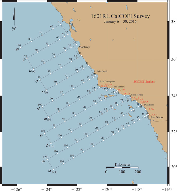
The area covered during this survey will be from San Diego to San Francisco and extend approximately 200 miles offshore (please see appendices 1b & 2a in Cruise Instructions PDF). -
Summary of Objectives
Survey the distributions and abundances of pelagic fish stocks, their prey, and their biotic and abiotic environments in the area of the California Current between San Francisco, California and San Diego, California.
The following are specific objectives for the winter CalCOFI.- I.D.1. Continuously sample pelagic fish eggs using the Continuous Underway Fish Egg Sampler (CUFES). The data will be used to estimate the distributions and abundances of spawning hake, anchovy, mackerel, and early spawning Pacific sardine.
- I.D.2. Continuously sample multi-frequency acoustic backscatter using the Simrad EK60 and the Simrad ME70. The data will be used to estimate the distributions and abundances of coastal pelagic fishes (e.g., sardine, anchovy, and mackerel), and krill species.
- I.D.3. Continuously sample sea-surface temperature, salinity, and chlorophyll-a using a thermosalinometer and fluorometer. These data will be used to estimate the physical oceanographic habitats for target species.
- I.D.4. Continuously sample air temperature, barometric pressure, and wind speed and direction using an integrated weather station.
- I.D.5. Sample profiles of seawater temperature, salinity, chlorophyll-a, nutrients, and phytoplankton using a CTD with water-sampling rosette and other instruments at prescribed stations. Measurements of extracted chlorophyll and phaeophytin will be obtained with a fluorometer. Primary production will be measured as C14 uptake in a six hour in situ incubation. Nutrients will be measured with an auto-analyzer. These data will be used to estimate primary productivity and the biotic and abiotic habitats for target species.
- I.D.6. Sample the light intensity in the photic zone using a standard secchi disk once per day in conjunction with a daytime CTD station. These data will be used to interpret the measurements of primary production.
- I.D.7. Sample plankton using a CalBOBL (CalCOFI Bongo Oblique) at prescribed stations. These data will be used to estimate the distributions and abundances of ichthyoplankton and zooplankton species.
- I.D.8. Sample plankton using a Manta (neuston) net at prescribed stations. These data will be used to estimate the distributions and abundances of ichthyoplankton species.
- I.D.9. Sample the vertically integrated abundance of fish eggs using a Pairovet net at prescribed stations. These data will be used to quantify the abundances and distributions of fish eggs.
- I.D.10. Sample plankton using a PRPOOS (Planktonic Rate Processes in Oligotrophic Ocean Systems net) at all prescribed CalCOFI stations on lines 90.0 and 80.0 as well as stations out to and including station 70.0 on lines 86.7 and 83.3 and station 81.8 46.9. PRPOOS will not be towed on SCCOOS stations. These data will be used in analyses by the LTER (Long Term Ecological Research) project.
- I.D.11. Continuously sample profiles of currents using the RDI/Teledyne Acoustic Doppler Current Profiler. This will be dependent on the ability to sync the ADCP’s output with the EK60 and ME70. The EK60 and ME70 will hold priority over the ADCP.
- I.D.12. Continuously observe, during daylight hours, seabirds and mammals. These data will be used to estimate the distributions and abundances of seabirds and marine mammals.
-
Participating Institutions
- I.E.1 Southwest Fisheries Science Center (SWFSC)
- I.E.2 Scripps Institution of Oceanography (SIO)
- I.E.3 Farallon Institute Advanced Ecosystem Research (FIAER)
Participants - please refer to the Cruise Instructions pdf or Cruise Prospectus
**Note: Acoustic Calibration staff to be transferred ashore via small boat following completion of calibration efforts.
*SIO, MBARI and SWFSC personnel will be transferred ashore or on board in Monterey, California by small boat at the completion of line 76.7. Both parties will be transported by Vessel Assist or comparable. Company(s) performing the transport will be contacted by SWFSC personnel prior the January 6 sailing date and prior to arrival in Monterey to arrange services.
-
Administrative
-
Points of Contacts:
- Chief Scientist/alternate: David Griffith/Amy Hays (858-546-7155/858-546-7130); 8901 La Jolla Shores Drive, La Jolla, CA, 92037 (This email address is being protected from spambots. You need JavaScript enabled to view it./This email address is being protected from spambots. You need JavaScript enabled to view it.)
- Project Operation Leads: Sam McClatchie (858-546-7183); 8901 La Jolla Shores Drive, La Jolla, CA, 92037 (This email address is being protected from spambots. You need JavaScript enabled to view it.)
- Ops Officer: LT Amber Payne (619-230-0331) NOAA Ship Reuben Lasker (This email address is being protected from spambots. You need JavaScript enabled to view it.)
-
Points of Contacts:
-
Diplomatic Clearances
None Required. -
Licenses and Permits
- All marine mammal work is covered under a federal research permit NMFS Permit 727-1915 issued to Dr. John Hildebrand of SIO
- All ichthyoplankton collections are covered under an MOU (Memo of Understanding) between the California Department of Fish and Game, the Southwest Region, National Marine Fisheries Service, NOAA and the Southwest Fisheries Science Center, National Marine Fisheries Service, NOAA.
- CDFW ON April 2, 2015 to NOAA-SWFSC-FRD-Cisco Werner(SC-12372)
II. Operations
-
A. Project Itinerary
- January 6: Calibration in San Diego Bay, CA (see attached Appendix 1.c.)
- January 6: Depart San Diego, CA – CalCOFI Leg I
- January 24: Small Boat Transfer via Monterey, CA
- January 24 - 29: CalCOFI Leg II
- January 30: Arrive San Diego, CA
B. Staging and De-staging
Staging for CalCOFI requires two full days. Staging and de-staging will be conducted in San Diego, CA at 10th Avenue Marine Terminal
C. Operations to be Conducted
-
II.C.1. Underway Operations
- II.C.1.a. Thermosalinometer sampling - The ship will provide and maintain a thermosalinometer (TSG), which is calibrated and in working order, for continuous measurement of surface water temperature and salinity. A backup unit (calibrated and in working order) will also be provided by the vessel and remain aboard during the project. The Scientific Computing System (SCS) will serve as the main data collection system. All SCS data will be provided to SWFSC personnel at the completion of the project.
-
II.C.1.b. Acoustics: If calibration of the EK60 echo sounders cannot be achieved while the ship is dockside prior to sailing, calibration of the Simrad EK60 echosounders will be performed at the beginning of the project (requiring approximately 6 hours). Prior to calibrating, the EK60 and ME70 transducers must be cleaned of all biofouling. The ship will sail on January 6, anchor in an area with greater than 10 meters beneath the transducers, in San Diego Bay, San Diego, and calibrate. A CTD will be cast to within two meters of the seabed and the temperature, salinity, sound speed, and dissolved oxygen versus depth data will be provided to the Acoustician. Thecenter board will remain in the retracted position. Three motorized down-riggers, two on one side of the vessel and one on the other, will be used to swing a 38.1-mm diameter sphere made from tungsten carbide and 6% cobalt beneath the center board mounted transducers.
The EK60 echosounders will be operated using EK80 software at 18, 38, 70, 120, 200 and 333 kHz and interfaced to a data acquisition system to estimate small pelagic fish and krill biomasses between 10 and 250 m. The ME70 will be operated with a configuration that does not cause crosstalk with the EK60 echosounders. The transmit pulses and logging ranges of the EK60s and ME70 will be optimized for local seabed depth using EK80 adaptive logger software (EAL). Also, using a combination of the EAL, an LCR meter, and a multiplexer (ZMUX), ambient noise and the electrical impedances of the EK60 transducers will be periodically measured and the data will be logged with data from the SCS to monitor and characterize the dynamic system calibration and signal-to-noise ratio versus the environment.
Prior to the survey, a plate with a sound speed sensor and a pan-tilt-zoom camera will be attached to the retractable centerboard. These instruments will be used to monitor the sound speed at the transducer faces to improve calibration accuracy, and to observe the presence and behaviors of epi-pelagic animals, respectively. Data from the sound speed sensor will be input to the SCS and also logged with the ZMUX software .
It is requested that the center board will be extended to mid-depth (ca. transducers at 7.5 m), during all survey operations, with CO approval based on navigational safety. Any changes to this depth will affect scientific data acquisition and should be reported to the acoustic-system operator(s).
The vessel's Simrad ES60 depth sounder (or comparable sounder located on the bridge) and Doppler current meter may be used minimally at the discretion of the Commanding Officer, but will normally remain off while underway. The ship shall inform the Cruise Leader of any use of the vessel's sounders, as it interferes with the signals received on the EK60s and ME70 that will be used continuously. - II.C.1.c. ADCP: The ship’s ADCP should run continuously and be logged to a data acquisition system. Complete system settings will be provided by the oceanographer, but will include 5-minute averaging of currents, AGC and 4 beam returns in 60 8-meter bins. The ADCP transmissions will be triggered by, and thereby synchronized with, the EK60s to avoid cross talk. If synchronization of the ADCP is not achievable, the ADCP will only be active during night hours and while on station.
-
II.C.1.d. CUFES: The egg pump will be mounted inside the ship’s hull drawing water from a depth of three meters. During leg I, Tthe pump will run continuously between stations to sample any pelagic fish eggs. Approximately 640 liters/minute is sent through a concentrator which filters all material larger than 505µm. The sieved material is then collected and identified. All fish eggs are identified to lowest taxa, counted and entered into the data acquisition software. Each sample entry is coupled with sea surface temperature, geographical position, wind speed and direction, date and time, and surface salinity. Sampling intervals will vary in length, depending on the number of fish eggs seen, from five to 30 minutes.
It is requested that prior to departure on January 6 that the CUFES intake be cleared from all marine growth. - II.C.1.e. Bird Observations: During daylight hours a bird observer will be posted on the flying bridge to identify and count birds while the ship is underway during project transects.
- II.C.1.f. Acoustic hydrophone: During transit between most daylight stations, an acoustic hydrophone array will be towed from the stern at a distance of 300 meters with a deck loaded winch to record sounds from marine mammals. The winch is 440V 3-phase with a deck pattern of 4.5 by 4.5 feet. Upon approaching a station, a sonobuoy will be deployed one nautical mile prior to stopping for station work.
-
II.C.2. Station Operations
Each standard station will include the following:-
II.C.2.a. CTD/Rosette consisting of 24 10-liter hydrographic bottles will be lowered to approximately 500 meters (depth permitting) at each station to measure physical parameters and collect water at discrete depths for analysis of: salinity, nutrients, oxygen, chlorophyll, etc. Casts conducted on line 66.7 will be to a depth of 1000 meters.
NOTE: SIO will provide their own CTD sensor and 24 bottle (10 liter) rosette unit for use on leg I. Please record CTD deployed, CTD at depth and CTD recovered for SCS. -
II.C.2.b. CalBOBL (CalCOFI Bongo): standard oblique plankton tow with 300 meters of wire out, depth permitting, using paired 505 ?m mesh nets with 71 cm diameter openings. The technical requirements for this tow are: Descent wire rate of 50 meters per minute and an ascent wire rate of 20 meters per minute. All tows with ascending wire angles lower than 38° or higher than 51° in the final 100 meters of wire will be repeated. Additionally, a 45° wire angle should be closely maintained during the ascent and descent of the net frame. A self-contained LOPC (Laser Optical Particle Counter) will be mounted in the port side opening during each tow. The port side sample will be preserved in buffered ethanol at every station.
Please record Bongo deployed and Bongo recovered for SCS. -
II.C.2.c. Manta net (neuston) tow: using a 505 ?m mesh net on a frame with a mouth area of 0.1333 m². Tows are 15 minutes in duration at towing speed of approximately 1.5 - 2.0 knots. Wire angles should be kept between 15° and 25°.
Please record Manta deployed and Manta recovered in SCS. -
II.C.2.d. Pairovet net: will be fished from 70 meters to the surface (depth permitting) using paired 25 cm diameter 150 ?m mesh nets. The technical requirements for Pairovet tows are: Descent rate of 70 meters per minute, a terminal depth time of 10 seconds and an ascent rate of 70 meters per minute. All tows with wire angles exceeding 15° during the ascent will be repeated.
Please record Pairovet deployed and Pairovet recovered for SCS. -
II.C.2.e. PRPOOS (Planktonic Rate Processes in Oligotrophic Ocean Systems) net will be taken at all leg I stations on line 90.0 and 80.0 as well as stations out to and including station 70.0 on lines 86.7 and 83.3 and station 81.8 46.9. These stations are occupied as part of the LTER (Long Term Ecological Research) project. The mesh of the PRPOOS net is 202 ?m and the tow is a vertical cast up from 210 meters. The technical requirements for the PRPOOS tows are: Decent rate of 40 meters per minute, a terminal depth time of 20 seconds and an ascent rate of 50 meters per minute.
Please record PRPOOS deployed and PRPOOS recovered for SCS. - II.C.2.f. Primary productivity: at about 1100 hours on each day of leg I a primary productivity CTD cast consisting of six 10-liter hydrographic bottles (mounted on CTD frame) will be carried out. The cast arrangement will be determined by a Secchi disc observation. This cast will be in conjunction with an already scheduled station. The purpose of the cast is to collect water from six discrete depths for daily in situ productivity experiments. Measurements of extracted chlorophyll and phaeophytin will be obtained with a fluorometer. Primary production will be measured as C14 uptake in a six hour in situ incubation. Nutrients will be measured with an auto-analyzer. All radioisotope work areas will be given a wipe test before the departure of the SIO technical staff. Primary productivity on leg I after line 76.7 will not be measured.
-
II.C.2.g. A light meter (Secchi disk) will be used to measure the light intensity in the euphotic zone once a day with the primary productivity cast and all daytime stations.
Please record Secchi deployed and Secchi recovered for SCS. - II.C.2.h. Weather observations.
-
II.C.3.a. Order of Operations for each standard station:
1) CTD to 515 meters with 24 bottle rosette (depth permitting).
2) Secchi disk (daylight stations only, Secchi will be first prior to CTD on Primary Productivity station of the day which is typically 0900-1100).
3) PRPOOS net tow [lines 90.0,86.7 (out to station 70), 83.3 (out to station 70) and 80.0 ; station 81.8 46.9]. No PRPOOS on near shore SCCOOS stations. Total of 35 stations).
4) Pairovet net tow (on all lines out to station 70.0 but not to include near shore SCCOOS).
5) Manta net tow (on all stations except for near shore SCCOOS).
6) Bongo net tow (on all stations). - II.C.3.b. Plankton Nets, Oceanographic Sampling Devices, Video Camera and ROV Deployments: The SWFSC deploys a wide variety of gear to sample the marine environment during all of their research projects. These types of gear are not considered to pose any risk to protected species and are therefore not subject to specific mitigation measures. However, the OOD and crew monitor for any unusual circumstances that may arise at a sampling site and use their professional judgment and discretion to avoid any potential risks to protected species during deployment of all research equipment.
-
Marine mammal watches are now a standard part of conducting fisheries research activities, particularly those that use gear (e.g., longlines and mid-water trawls) known to interact with marine mammals or that we believe have a reasonable likelihood of doing so in the future. Marine mammal watches are conducted in two ways. First, watches are conducted by lookouts (those navigating the vessel and other crew) at all times when the vessel is being operated. Second, marine mammal watches and monitoring occur for 30 minutes prior to deployment of gear, and they continue until gear is brought back on board, for longlines and mid-water trawl gear. Watches in the first category are not done by dedicated staff; these personnel primary duties as lookout according to the Rules of the Road are “maintaining a proper lookout by sight and hearing as well as by all available means appropriate tin the prevailing circumstances and conditions so as to make a full appraisal of the situation and of the risk of collision.” Watches in the second category are done by dedicated scientists with no other responsibilities during the watch period. If marine mammals are sighted within 1 nm of the planned set location then the sampling station is either moved or canceled. Watch-standers record the estimated species and number of animals present and their behaviors. This information can be valuable in understanding whether some species may be attracted to vessels or gear. While underway on leg I:
We will have a bird observer on the flying bridge during all daylight transects.
We will have 2 marine mammal observers on the flying bridge during all daylight transects.
We will have a marine mammal acoustician with a towed hydrophone. The hydrophone will be towed off the stern at a distance of 300 meters between daylight stations. The hydrophone will be deployed at a ship speed of 5 knots while leaving a station . Once deployed, ship can travel at full speed. The hydrophone can be retrieved at ship’s full speed.
At 1 mile prior to each daylight station marine mammal observers will deploy 2 sonobuoys. The hydrophone will be retrieved at this time.
Communication will be open to bridge during all hydrophone deployments and retrievals.
-
II.C.2.a. CTD/Rosette consisting of 24 10-liter hydrographic bottles will be lowered to approximately 500 meters (depth permitting) at each station to measure physical parameters and collect water at discrete depths for analysis of: salinity, nutrients, oxygen, chlorophyll, etc. Casts conducted on line 66.7 will be to a depth of 1000 meters.
Pending (Refer to Cruise Instructions PDF for the following)
D. Dive Plan
E. Applicable Restrictions
Conditions which preclude normal operations:
In the event of poor weather conditions, we will work with the ship’s officers on developing the best strategy for completion of all stations safely.
We have replacement gear for all operations. Equipment failure should not impact our project.
III. Equipment
A. Equipment and Capabilities provided by the ship (itemized)
B. Equipment and Capabilities provided by the scientists (itemized)
IV. Hazardous Materials
A. Policy and Compliance
B. Radioactive Isotopes
C. Inventory (itemized) of Radioactive Materials
VI. Disposition of Data and Reports
A. Data Responsibilities
B. Pre and Post Project Meeting
C. Ship Operation Evaluation Report
VII. Miscellaneous
A. Meals and Berthing
B. Medical Forms and Emergency Contacts
C. Shipboard Safety
D. Communications
E. IT Security
F. Foreign National Guests Access to OMAO Facilities and Platforms
Responsibilities of the Chief Scientist:
Responsibilities of the Commanding Officer:
Responsibilities of the Foreign National Sponsor:
Appendices
Station/Waypoint List