I. Overview - Project Instructions complete pdf
Brief Summary and Project Period - Survey the distributions and abundances of pelagic fish stocks, their prey, and their biotic and abiotic environments in the area of the California Current between San Francisco, California and San Diego, California during the period of January 10 to February 2, 2013.
Summary of Objectives - Survey the distributions and abundances of pelagic fish stocks, their prey, and their biotic and abiotic environments in the area of the California Current between San Francisco, California and San Diego, California
The following are specific objectives for the Winter CalCOFI.
- Continuously sample pelagic fish eggs using the Continuous Underway Fish Egg Sampler (CUFES). The data will be used to estimate the distributions and abundances of spawning hake, anchovy, mackerel, and early spawning Pacific sardine.
- Continuously sample multi-frequency acoustic backscatter using the Simrad EK60. The data will be used to estimate the distributions and abundances of coastal pelagic fishes (e.g., sardine, anchovy, and mackerel), and krill species.
- Continuously sample sea-surface temperature, salinity, and chlorophyll-a using a thermosalinometer and fluorometer. These data will be used to estimate the physical oceanographic habitats for target species.
- Continuously sample air temperature, barometric pressure, and wind speed and direction using an integrated weather station.
- Sample profiles of seawater temperature, salinity, chlorophyll-a, nutrients, and phytoplankton using a CTD with water-sampling rosette and other instruments at prescribed stations. Measurements of extracted chlorophyll and phaeophytin will be obtained with a fluorometer. Primary production will be measured as C14 uptake in a six hour in situ incubation. Nutrients will be measured with an auto-analyzer. These data will be used to estimate primary productivity and the biotic and abiotic habitats for target species.
- Sample the light intensity in the photic zone using a standard secchi disk once per day in conjunction with a daytime CTD station. These data will be used to interpret the measurements of primary production.
- Sample plankton using a CalBOBL (CalCOFI Bongo Oblique) at prescribed stations. These data will be used to estimate the distributions and abundances of ichthyoplankton and zooplankton species.
- Sample plankton using a Manta (neuston) net at prescribed stations. These data will be used to estimate the distributions and abundances of ichthyoplankton species.
- Sample the vertically integrated abundance of fish eggs using a Pairovet net at prescribed stations. These data will be used to quantify the abundances and distributions of fish eggs.
- Sample plankton using a PRPOOS (Planktonic Rate Processes in Oligotrophic Ocean Systems net) at all prescribed CalCOFI stations on lines 90.0 and 80.0 as well as stations out to and including station 70.0 on lines 86.7 and 83.3. These data will be used in analyses by the LTER (Long Term Ecological Research) project.
- Continuously sample profiles of currents using the RDI/Teledyne Acoustic Doppler Current Profiler. Continuously observe, during daylight hours, seabirds and mammals. These data will be used to estimate the distributions and abundances of seabirds and marine mammals.
- Southwest Fisheries Science Center (SWFSC)
- Scripps Institution of Oceanography (SIO)
- Monterey Bay Aquarium Research Institute (MBARI)
- Farallon Institute Advanced Ecosystem Research (FIAER)
Administrative Points of Contacts:
- Chief Scientist/alternate: David Griffith/Amy Hays (858-546-7155/858-546-7130); 8604 La Jolla Shores Drive, La Jolla, CA, 92037 (This email address is being protected from spambots. You need JavaScript enabled to view it./This email address is being protected from spambots. You need JavaScript enabled to view it.)
- Project Operation Leads: Sam McClatchie (858-546-7183); 8604 La Jolla Shores Drive, La Jolla, CA, 92037 (This email address is being protected from spambots. You need JavaScript enabled to view it.)
- Ops Officer: LT Andrew Colegrove (206-427-2374) NOAA Ship Bell M. Shimada (This email address is being protected from spambots. You need JavaScript enabled to view it.)
Operating Area 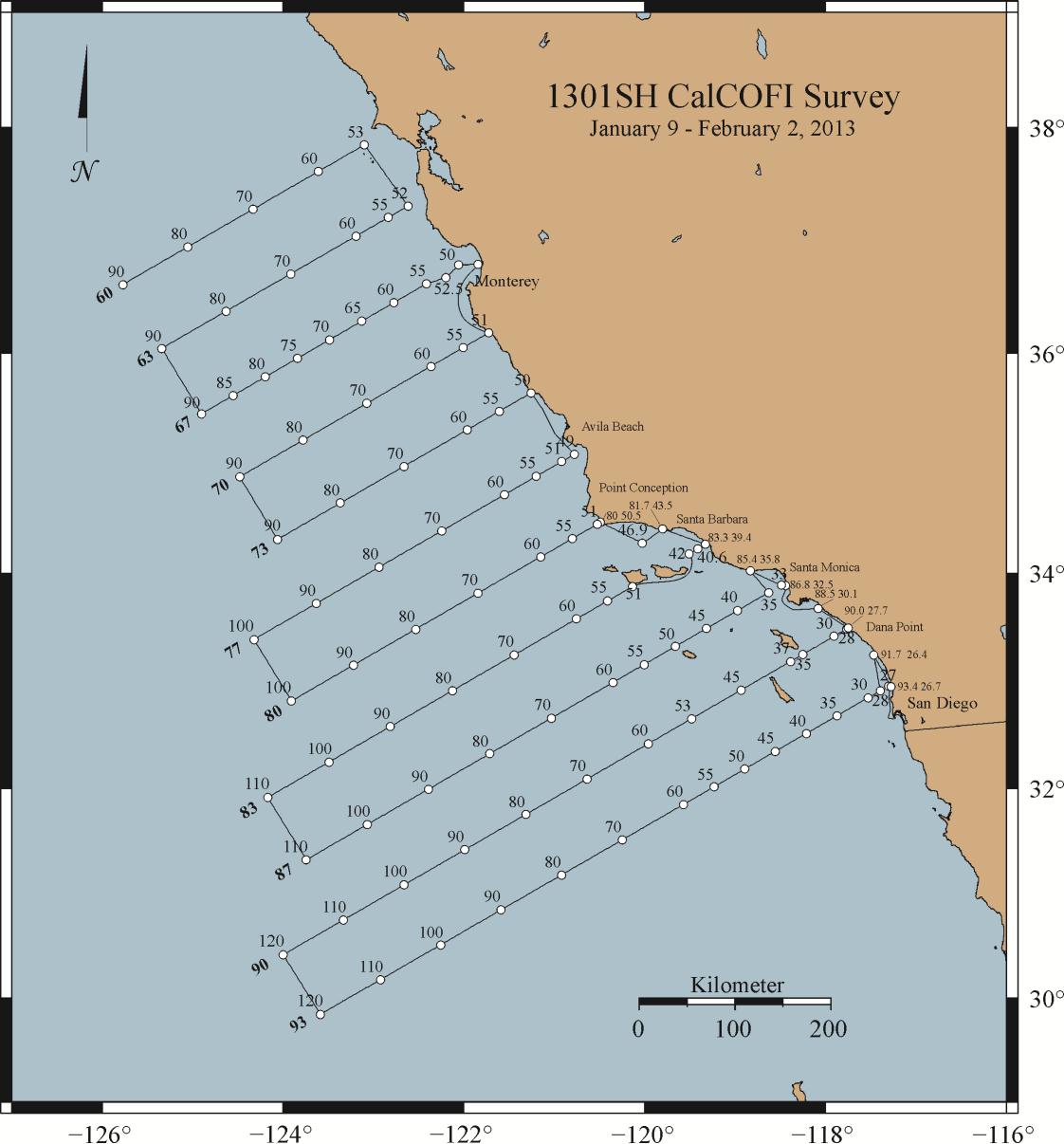 II.
II.
Operations
-
Project Itinerary
- SD Transit: January 4: Depart Newport, OR
- January 7: Arrive San Diego, CA
- January 10: Calibration in San Diego Bay, CA (see attached Appendix 1.b.)
- Leg I: January 10: Depart San Diego, CA - CalCOFI
- January 26: Small Boat Transfer via Monterey Bay, CA
- February 2: Arrive San Diego, CA
- NPT Transit: February 4: Depart San Diego, CA
- February 7: Arrive Newport, OR
B. Staging and Destaging: staging and destaging will be conducted in San Diego, CA (pier TBD).
C. Operations to be Conducted
-
II.C.1. Underway Operations
- II.C.1.a. Thermosalinometer sampling - The ship will provide and maintain a thermosalinometer (TSG), which is calibrated and in working order, for continuous measurement of surface water temperature and salinity. A backup unit (calibrated and in working order) will also be provided by the vessel and remain aboard during the cruise. The Scientific Computing System (SCS) will serve as the main data collection system. All SCS data will be provided to SWFSC personnel at the completion of the cruise.
- II.C.2.b. Acoustics: Calibration of the Simrad EK60 echosounders will be performed at the beginning of the cruise (requiring 6 hours). The ship will sail at 0800 on January 9, anchor in San Diego Bay, San Diego, and calibrate. The keel will remain in the retracted position. Three motorized down-riggers, two on one side of the vessel and one on the other, will be used to swing a 38.1 mm diameter tungsten carbide sphere beneath the keel-mounted transducers. The EK60 echosounder will be operated at 18, 38, 70, 120 and 200 kHz and interfaced to a data acquisition system to estimate small pelagic fish and krill biomasses between 10 and 250 m. The instrumented keel will be extended to mid-depth (ca. transducers at 7.5m), during all survey operations. Any changes to this depth should be avoided, and reported to the acoustic-system operator(s). The vessel's Simrad ES60 depth sounder and Doppler current meter may be used minimally at the discretion of the Commanding Officer, but will normally remain off while underway. The ship shall inform the Cruise Leader of any use of the vessel's sounders, as it interferes with the signals received on the EK60s that will be used continuously.
- II.C.2.c. ADCP: The ship’s ADCP should run continuously and be logged to a data acquisition system. Complete system settings will be provided by the oceanographer, but will include 5-minute averaging of currents, AGC and 4 beam returns in 60 8-meter bins. The ADCP transmissions will be triggered by, and thereby synchronized with, the EK60s to avoid cross talk.
- II.C.2.d. CUFES: The egg pump will be mounted inside the ship’s hull drawing water from a depth of three meters. During leg I, the pump will run continuously between stations to sample any pelagic fish eggs. Approximately 640 liters/minute is sent through a concentrator which filters all material larger than 505µm. The sieved material is then collected and identified. All fish eggs are identified to lowest taxa, counted and entered into the data acquisition software. Each sample entry is coupled with sea surface temperature, geographical position, wind speed and direction, date and time, and surface salinity. Sampling intervals will vary in length, depending on the number of fish eggs seen, from five to 30 minutes.
- II.C.2.e. Bird Observations: During daylight hours a bird observer will be posted on the flying bridge to identify and count birds while the ship is underway during cruise transects.
- II.C.f. Acoustic hydrophone: During transit between most daylight stations, an acoustic hydrophone array will be towed from the stern at a distance of 300 meters with a deck loaded winch to record sounds from marine mammals. The winch is 440V 3-phase with a deck pattern of 4.5 by 4.5 feet. Upon approaching a station, a sonobuoy will be deployed one nautical mile prior to stopping for station work.
-
II.C.2. Station Operations: each standard station will include the following:
- II.C.2.a. CTD/Rosette consisting of 24 10-liter hydrographic bottles will be lowered to approximately 500 meters (depth permitting) at each station to measure physical parameters and collect water at discrete depths for analysis of: salinity, nutrients, oxygen, chlorophyll, etc. Casts conducted on line 66.7 will be to a depth of 1000 meters. NOTE: SIO will provide their own CTD sensor and 24 bottle (10 liter) rosette unit for use on leg I. Please record CTD deployed, CTD at depth and CTD recovered for SCS.
- II.C.2.b. CalBOBL (CalCOFI Bongo): standard oblique plankton tow with 300 meters of wire out, depth permitting, using paired 505 .m mesh nets with 71 cm diameter openings. The technical requirements for this tow are: Descent wire rate of 50 meters per minute and an ascent wire rate of 20 meters per minute. All tows with ascending wire angles lower than 38° or higher than 51° in the final 100 meters of wire will be repeated. Additionally, a 45° wire angle should be closely maintained during the ascent and descent of the net frame. A self-contained LOPC (Laser Optical Particle Counter) will be mounted in the port side opening during each tow. The port side sample will be preserved in buffered ethanol at every station. Please record Bongo deployed and Bongo recovered for SCS.
- II.C.2.c. Manta net (neuston) tow: using a 505 .m mesh net on a frame with a mouth area of 0.1333 m². Tows are 15 minutes in duration at towing speed of approximately 1.5 - 2.0 knots. Wire angles should be kept between 15° and 25°. Please record Manta deployed and Manta recovered in SCS.
- II.C.2.d. Pairovet net: will be fished from 70 meters to the surface (depth permitting) using paired 25 cm diameter 150 .m mesh nets at all stations. The technical requirements for Pairovet tows are: Descent rate of 70 meters per minute, a terminal depth time of 10 seconds and an ascent rate of 70 meters per minute. All tows with wire angles exceeding 15° during the ascent will be repeated. Please record Pairovet deployed and Pairovet recovered for SCS.
- II.C.2.e. PRPOOS (Planktonic Rate Processes in Oligotrophic Ocean Systems) net will be taken at all leg I stations on line 90.0 and 80.0 as well as stations out to and including station 70.0 on lines 86.7 and 83.3. These stations are occupied as part of the LTER (Long Term Ecological Research) project. The mesh of the PRPOOS net is 202 .m and the tow is a vertical cast up from 210 meters. The technical requirements for the PRPOOS tows are: Decent rate of 40 meters per minute, a terminal depth time of 20 seconds and an ascent rate of 50 meters per minute. Please record PRPOOS deployed and PRPOOS recovered for SCS.
- II.C.2.f. Primary productivity: at about 1100 hours on each day of leg I a primary productivity CTD cast consisting of six 10-liter hydrographic bottles (mounted on CTD frame) will be carried out. The cast arrangement will be determined by a Secchi disc observation. This cast will be in conjunction with an already scheduled station. The purpose of the cast is to collect water from six discrete depths for daily in situ productivity experiments. Measurements of extracted chlorophyll and phaeophytin will be obtained with a fluorometer. Primary production will be measured as C14 uptake in a six hour in situ incubation. Nutrients will be measured with an auto-analyzer. All radioisotope work areas will be given a wipe test before the departure of the SIO technical staff. Primary productivity on leg I after line 76.7 will be incubated over a 24 hour cycle rather than a daylight cycle.
- II.C.2.g. A light meter (Secchi disk) will be used to measure the light intensity in the euphotic zone once a day with the primary productivity cast and all daytime stations. Please record Secchi deployed and Secchi recovered for SCS.
- II.C.2.h. Weather observations.
II.C.3.a. Order of Operations for each standard station:
- CTD to 515 meters with 24 bottle rosette (depth permitting).
- Secchi disk (daylight stations only, Secchi will be first prior to CTD on Primary Productivity station of the day which is typically 0900-1100).
- PRPOOS net tow [lines 90.0,86.7 (out to station 70), 83.3 (out to station 70) and 80.0 only, total of 35 stations).
- Pairovet net tow (on all lines out to station 70.0 but not to include near shore SCCOOS).
- Manta net tow (on all stations except for near shore SCCOOS).
- Bongo net tow (on all stations).
While underway on leg I:
- We will have a bird observer on the flying bridge during all daylight transects.
- We will have 2 marine mammal observers on the flying bridge during all daylight transects.
- We will have a marine mammal acoustician with a towed hydrophone. The hydrophone will be towed off the stern at a distance of 300 meters between daylight stations. The hydrophone will be deployed at a ship speed of 5 knots while leaving a station. Once deployed, ship can travel at full speed. The hydrophone can be retrieved at ship’s full speed. At 1 mile prior to each daylight station marine mammal observers will deploy 2 sonobuoys. The hydrophone will be retrieved at this time. Communication will be open to bridge during all hydrophone deployments and retrievals.