 |
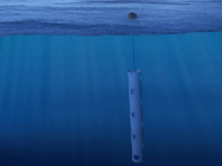
The Institute for Computational Earth System Science (ICESS) utilizes Pacific Gyre GPS/ Mobitex™ "Microstar" drifters to observe and study near-shore ocean circulation off the Southern California coast. The drifters record their position with GPS every 10 minutes and transmit their position data in near real-time to a web-based host computer using the Mobitex narrow band, data-only, cellular communications system. This sort of time and space resolution enables characteristic near-shore circulation patterns to be properly resolved. The drifters give direct observations of paths taken by freely floating objects at the ocean surface such as spilled oil, other pollutants, or things lost at sea.
ICESS Lagrangian Drifter, Near-Shore Ocean Circulation Research Real-Time Drifter Tracking.
Click to see real-time drifter data from CalCOFI deployments.
SPECIFIC DEPLOYMENT LOCATIONS (13 drifters total, deployed at 7 stations)
sta 86.7 40.0 - 2 drifters; #93561 and #93562; ~100 m separation
sta 86.7 45.0 - 2 drifters; #93563 and #93564; ~100 m separation
sta 86.7 50.0 - 2 drifters; #93565 and #93566; ~100 m separation
sta 86.7 55.0 - 2 drifters; #93567 and #93568; ~100 m separation
sta 83.3 60.0 - 1 drifter; #93569
sta 83.3 55.0 - 2 drifters; #93570 and #93571; ~100 m separation
sta 83.3 51.0 - 2 drifters; #93572 and #93573; ~100 m separation
QUESTIONS
Carter Ohlmann
ICESS/UCSB
This email address is being protected from spambots. You need JavaScript enabled to view it.
 |
Additional Information |