| Cruise Summary: | All 75 scheduled stations were successfully occupied although station sequence was re-ordered to occupy northern stations during calmer conditions. Warm, relatively calm ocean conditions seen in July persist supporting the prediction of a weakening 2014 El Nino. |
| Data Files: | 1411NH Preliminary Plots; 1411NH CTD (raw) Cast Files; 1411NH CTD + Btl FinalQC Data |
| Cruise Dates: | 08 - 23 Nov 2014 (Sat - Sun) |
| Load Dates: | 05 - 07 Nov 2014 (Wed - Fri) in San Diego, location 10th Ave Marine Terminal, San Diego |
| Offload Date: | 24 Nov 2014 (Mon) |
| Ship: | SIO RV New Horizon; (CalCOFI NH Layout) |
| Station plan: | 75 Standard (66 CalCOFI + 9 SCCOOS) |
| Cruise Forms: | Ship Scheduling User Portal; Physical Ability to Work At Sea; Drug, Alcohol, & Sexual Harassment Policy; Medical Questionaire (optional) |
| Cruise Map: |  |
| Contacts: | James Wilkinson, Chief Scientist, SIO-IOD |
| Amy Hays, NMFS (Fisheries Technical Coordinator) |
Please note that the anomalies are based on 50-year harmonics (1949-1999) and these data are 1m binavg Seasoft-processed CTD data that have not gone through thorough quality control checks or bottle corrections. They are presented to give a general impression of current conditions. Final data plots will be published after all data are processed.
 |
 |
 |
 |
 |
 |
 |
 |
 |
 |
 |
 |
 |
 |
 |
| CTD Processing Summary CalCOFI 1411NH CTD Final Data | |||
| Download 1411NH CTD raw cast files zipped | Download 1411NH FinalQC CTD + bottle data & plots | ||
| General CTD Notes - data acquisition notes, logistics, processing - see below | |||
| CTD sensor corrections derived by comparing 4 secs of CTD sensor data (prior to bottle closure) to bottle samples | |||
| Dual T, S, & O2 | Primary Sensor | Secondary Sensor | |
| Salinity offset (bottle - CTD salinity; > 350m only; Seabird SBE4) | -0.0042 | -0.0019 | |
| Oxygen ml/L (dual Seabird SBE43) | y = 1.0249x - 0.0131 R² = 0.9998 |
y = 1.0486x - 0.0457 R² = 0.9997 |
|
| Oxygen umoles/Kg (dual Seabird SBE43) | y = 1.026x - 0.4136 R² = 0.9998 |
y = 1.0496x -1.8316 R² = 0.9996 |
|
| Single sensors | Linear | Polynomial | |
| Nitrate - ISUS 4sec ave voltage vs Bottle Nitrate (Satlantic MBARI-ISUS v2) | y = 27.413x - 6.8241 R² = 0.9938 |
||
| Fluorometer - linear & polynomial regressions |
y = 6.5605x - 0.2086 R² = 0.8037 |
y = 2.8207x2+5.8663x-0.1789 R² = 0.8059 |
|
 |
 |
||
 |
 |
||
 |
 |
||
| General notes: These are cast & final CTD Processing Notes from 1411NH cruise | |||
|
|||
|
CalCOFI 1411NH General Cast Notes: This cruise occupied 75 stations: 66 standard, & 9 SCCOOS. The station schedule was modified due to naval operations on lines 83 & 80 plus bad weather forecast. Refer to the map for the station order and cruise track. Coastal stations on line 83 & 80 (51, 50.5) & Santa Barbara Basin were done after lines 80 & 77 were completed. Cast 01 - sat at depth while prodo bottle depths were calculated Cast 03 - pressure offset of -0.05 was added pre-cast Cast 05 - bottle #8 was replaced after cast - bottom cap problem; #18 bottom valve replaced - leaky Cast 10 - ISUS not powered, no data; winch speed was over 60m/min for a brief time Cast 11 - upcast different than downcast between 350-300m Cast 12 - new ISUS battery installed - terminal was loose Cast 17 - bottle #17 did not close, used #16 for prodo Cast 22 - deep 3500m cast; PAR, ISUS + battery, pH sensors removed; O2 minimum at ~670m Cast 23 - upcast different than downcast, especially O2; transmissometer zeroed on downcast @~375m, worked on upcast Cast 26 - transmissometer dropped out below 400m, connector cleaned post-cast. Cast 27 - ~2.5hr delay to sta 90.45, Naval ops; transmissometer dropped @415m on downcast Cast 30 - transmissometer cut out @418m downcast Cast 31 - personnel exchange before prodo station 90.28 Cast 35 - CTD landed on bottom due to misread of Knudsen, seems fine but terminal data may be influenced by suspended materials Cast 36 - transmissometer outage at 453m downcast, upcast looks okay Cast 37 - bottle #10 no closure, lanyard hung up Cast 40 - transmissometer jumpy between 410-440m; rough weather, no net tows Cast 41 - rough weather; PAR and pH caps left on, both caps came back, pH buffer replaced post-cast Cast 42 - really rough weather, use loopedit to de-loop the slow ~27m/min downcast Cast 44 - transmissometer voltage zeroed @~460m on downcast but back at 515m Cast 45 - pressure offset -0.05 applied Cast 46 - pressure offset -0.05 applied again, deck pressure often increases when CTD lands hard Cast 48 - transmissometer out @~450m downcast Cast 49 - 54 - transmissometer out below ~400m downcast, really need a backup Cast 55 - calm night; transmissometer dropped after 450m Cast 56 - 57 - transmissometer worked all the way! Cast 58 - light rain during sample drawing; transmissometer good till ~470m downcast Cast 59 - big rolls, ship rocking; primary oxygen bio-fouled on upcast from ~125m; sensor replaced post-cast Cast 59 -61 - some deep noise in transmissometer Cast 62 - transmissometer worked full cast Cast 64 - ISUS battery not plugged in, no ISUS data; battery replaced after cast Cast 65-66 - transmissometer outage @380m and again @465m Cast 67 - 230m station; some strangeness on CTD acquisition PC, main plot went blank at 40m on upcast, data look fine but worth noting Cast 68 - 60m shallow sta, big rolls Cast 69 - SCCOOS sta 80.0 50.5, green water but not fluorescing much Cast 71 - Santa Barbara Basin, wind causing wire angle; transmissometer noisy File notes: 12Mar2015 |
|||
Platform: RV New Horizon
Project Number: SIO NH1423
 Project Title: CalCOFI 1411NH
Project Dates: November 8 2014 to November 25 2014
Prepared: August 20 2014
Chief Scientist: James R. Wilkinson, SIO
(Official NOAA Cruise Instructions PDF)
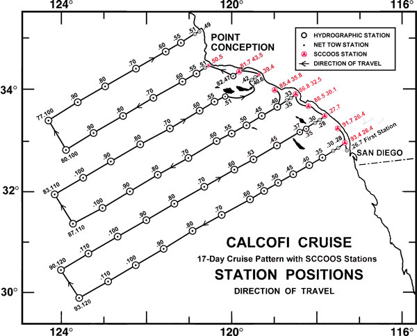
ITINERARY: Depart San Diego, California at 0800 on November 8, 2014. Proceed to first CalCOFI station 93.3/26.7 (position 32° 57.4'N/117° 18.3'W) and begin a standard CalCOFI pattern (see cruise track). The vessel will return to San Diego, California on November 25,
2014.
I. Overview
A. Brief Summary and Project Period - CalCOFI continues its 65-year hydrographic, fisheries, and ecosystem time-series survey of the Southern California Bight, occupying 75 stations. NOAA Fisheries will survey of the distributions and abundances of zooplankton, fish eggs & larvae plus their biotic and abiotic environments in the area of the California Current between Avila Beach, California and San Diego, California during the period of November 8 to November 25, 2014.
B. Service Level Agreements - Of the 18 DAS scheduled for this project, 2 DAS are funded by CCE-LTER II (NSF-OCE-BIO) and 16 DAS are funded by CalCOFI 2014/15 (NOAA-NMFS).
C. Operating Area - see map
D. Summary of Objectives - Ecosystem survey of the Southern California Bight, CalCOFI Lines 93.3 - 76.7. Oceanographic ecosystem survey, with biotic and abiotic components, of the California Current between Avila Beach, California and San Diego, California.
