Platform: RV New Horizon
Project Number: SIO NH1423
 Project Title: CalCOFI 1411NH
Project Dates: November 8 2014 to November 25 2014
Prepared: August 20 2014
Chief Scientist: James R. Wilkinson, SIO
(Official NOAA Cruise Instructions PDF)
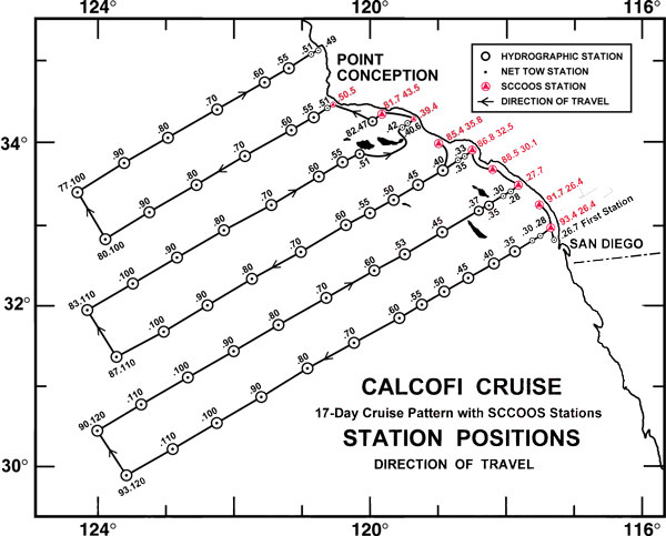
ITINERARY: Depart San Diego, California at 0800 on November 8, 2014. Proceed to first CalCOFI station 93.3/26.7 (position 32° 57.4'N/117° 18.3'W) and begin a standard CalCOFI pattern (see cruise track). The vessel will return to San Diego, California on November 25,
2014.
I. Overview
A. Brief Summary and Project Period - CalCOFI continues its 65-year hydrographic, fisheries, and ecosystem time-series survey of the Southern California Bight, occupying 75 stations. NOAA Fisheries will survey of the distributions and abundances of zooplankton, fish eggs & larvae plus their biotic and abiotic environments in the area of the California Current between Avila Beach, California and San Diego, California during the period of November 8 to November 25, 2014.
B. Service Level Agreements - Of the 18 DAS scheduled for this project, 2 DAS are funded by CCE-LTER II (NSF-OCE-BIO) and 16 DAS are funded by CalCOFI 2014/15 (NOAA-NMFS).
C. Operating Area - see map
D. Summary of Objectives - Ecosystem survey of the Southern California Bight, CalCOFI Lines 93.3 - 76.7. Oceanographic ecosystem survey, with biotic and abiotic components, of the California Current between Avila Beach, California and San Diego, California.
The following are specific objectives for the Fall CalCOFI.
I.D.1. Continuously sample multi-frequency acoustic backscatter using the Simrad EK60. The data will be used to estimate the distributions and abundances of coastal pelagic fishes (e.g., sardine, anchovy, and mackerel), and krill species.
I.D.2. Continuously sample sea-surface temperature, salinity, pH and chlorophyll-a using a thermosalinometer, pH meter and fluorometer. These data will be used to estimate the physical oceanographic habitats for target species.
I.D.3. Continuously sample air temperature, barometric pressure, and wind speed and direction using an integrated weather station.
I.D.4. Sample profiles of seawater temperature, salinity, chlorophyll-a, nutrients, and phytoplankton using a CTD with water-sampling rosette and other instruments at prescribed stations. Measurements of extracted chlorophyll and phaeophytin will be obtained with a fluorometer. Primary production will be measured as C14 uptake in a six hour in situ incubation. Nutrients will be measured with an auto-analyzer. These data will be used to estimate primary productivity and the biotic and abiotic habitats for target species.
I.D.5. Sample the light intensity in the photic zone using a standard secchi disk once per day in conjunction with a daytime CTD station. These data will be used to interpret the measurements of primary production.
I.D.6. Sample plankton using a CalBOBL (CalCOFI Bongo Oblique) at prescribed stations. These data will be used to estimate the distributions and abundances of ichthyoplankton and zooplankton species.
I.D.7. Sample plankton using a Manta (neuston) net at prescribed stations. These data will be used to estimate the distributions and abundances of ichthyoplankton species.
I.D.8. Sample the vertically integrated abundance of fish eggs using a Pairovet net at prescribed stations. These data will be used to quantify the abundances and distributions of fish eggs.
I.D.9. Sample plankton using a PRPOOS (Planktonic Rate Processes in Oligotrophic Ocean Systems net) at all prescribed CalCOFI stations on lines 90.0 and 80.0 as well as stations out to and including station 70.0 on lines 86.7 and 83.3. These data will be used in analyses by the LTER (Long Term Ecological Research) project.
I.D.10. Continuously sample profiles of currents using the RDI/Teledyne Acoustic Doppler Current Profiler.
I.D.11. Continuously observe, during daylight hours, seabirds and mammals. These data will be used to estimate the distributions and abundances of seabirds and marine mammals.
E. Participating Institutions
I.E.1 Southwest Fisheries Science Center (SWFSC)
I.E.2 Scripps Institution of Oceanography (SIO)
I.E.3 California Department of Fish & Wildlife (CDF&W)
F. Administrative
Points of Contacts:
Chief Scientist: James R Wilkinson (858-822-0674); MESOM 8880 Biological Grade, La Jolla CA, 92037 ( This email address is being protected from spambots. You need JavaScript enabled to view it. )
NOAA Contact: Amy Hays (858-546-7130); SWFSC 8604 La Jolla Shores Drive, La Jolla, CA, 92037 ( This email address is being protected from spambots. You need JavaScript enabled to view it. )
Project Operation Lead: Dr Dave Checkley (858-534-4228); 9500 Gilman Dr, 0218, La Jolla, CA, 92093 ( This email address is being protected from spambots. You need JavaScript enabled to view it. )
SIO-CalCOFI Supervisor: Dr Ralf Goericke (858-534-7970); 9500 Gilman Dr, 0206, La Jolla, CA, 92093 ( This email address is being protected from spambots. You need JavaScript enabled to view it. )
2. Licenses and Permits
All marine mammal work is covered under a federal research permit NMFS Permit 727-1915 issued to Dr. John Hildebrand of SIO. All ichthyoplankton collections are covered under an MOU (Memo of Understanding) between the California Department of Fish and Game, the Southwest Region, National Marine Fisheries Service, NOAA and the Southwest Fisheries Science Center, National Marine Fisheries Service, NOAA.
II. Operations
A. Project Itinerary
November 5: Load RV New Horizon at 10th Ave Marine Terminal, San Diego
November 6-7: Continue load and setup of RV New Horizon
November 8: Depart 10th Ave Marine Terminal at 0800
November 25: Return to San Diego, 10th Ave Marine Terminal by 1600
November 26: Offload CalCOFI 1411NH from RV New Horizon
B. Staging and De-staging
Staging for CalCOFI requires three days. Staging and de-staging will be conducted in San Diego, CA at 10th Ave Marine Terminal.
C. Operations to be Conducted
II.C.1. Underway Operations
II.C.1.a. Thermosalinometer sampling - The ship will provide and maintain a thermosalinometer (TSG), which is calibrated and in working order, for continuous measurement of surface water temperature and salinity. A backup unit (calibrated and in working order) will also be provided by the vessel and remain aboard during the cruise. The Meteorological System (MET) will serve as the main underway data collection system. SIO-CalCOFI will collect all underway data files at the conclusion of the cruise.
II.C.2.b. Acoustics: The vessel's Knudsen depth sounder and Doppler current meter will be used in conjunction with the EK60 acoustics system. The EK60 controls will be set to synchronize with the ADCP.
II.C.2.c. ADCP: The ship’s ADCP should run continuously and be logged to a data acquisition system. System settings will be provided by Jules Hammond. The ADCP transmissions will be triggered by, and thereby synchronized with, the EK60s to avoid cross talk.
II.C.2.d. Marine Mammal Observations: During daylight hours two observers will be posted on the bridge wings to identify and count marine mammals while the ship is underway during cruise transects.
II.C.2.e. Acoustic hydrophone: During transit between most daylight stations, an acoustic hydrophone array will be towed from the stern at a distance of 300 meters with a deck loaded winch to record sounds from marine mammals. The winch is 440V 3-phase with a deck pattern of 4.5 by 4.5 feet. Upon approaching a station, a sonobuoy will be deployed one nautical mile prior to stopping for station work.
II.C.2. Station Operations - Each standard station will include the following:
II.C.2.a. CTD/Rosette consisting of 24 10-liter hydrographic bottles will be lowered to approximately 500 meters (depth permitting) at each station to measure physical parameters and collect water at discrete depths for analysis of: salinity, nutrients, oxygen, chlorophyll, etc. NOTE: SIO-CalCOFI provides their own CTD sensor and 24 bottle (10 liter) rosette unit for use on leg I. 'CTD deployed', 'CTD at depth' and 'CTD recovered' events are recorded on the aft-control Event Log provided by CalCOFI.
II.C.2.b. CalBOBL (CalCOFI Bongo Oblique): standard oblique plankton tow with 300 meters of wire out, depth permitting, using paired 505 ?m mesh nets with 71 cm diameter openings. The technical requirements for this tow are: Descent wire rate of 50 meters per minute and an ascent wire rate of 20 meters per minute. All tows with ascending wire angles lower than 38° or higher than 51° in the final 100 meters of wire will be repeated. Additionally, a 45° wire angle should be closely maintained during the ascent and descent of the net frame. A self-contained LOPC (Laser Optical Particle Counter) will be mounted in the port side opening during each tow. The port side sample will be preserved in buffered ethanol at every station. 'Bongo deployed' and 'Bongo recovered' events are recorded on the aft-control Event Log provided by CalCOFI..
II.C.2.c. Manta net (neuston) tow: using a 505 ?m mesh net on a frame with a mouth area of 0.1333 m². Tows are 15 minutes in duration at towing speed of approximately 1.5 - 2.0 knots. Wire angles should be kept between 15° and 25°. 'Manta deployed' and 'Manta recovered' are recorded on the aft-control Event Log provided by CalCOFI.
II.C.2.d. Pairovet net: will be fished from 70 meters to the surface (depth permitting) using paired 25 cm diameter 150 um mesh nets at all stations out to and including station 70.0. The technical requirements for Pairovet tows are: Descent rate of 70 meters per minute, a terminal depth time of 10 seconds and an ascent rate of 70 meters per minute. All tows with wire angles exceeding 15° during the ascent will be repeated. 'Pairovet deployed' and 'Pairovet recovered' are recorded on the aft-control Event Log provided by CalCOFI.
II.C.2.e. PRPOOS (Planktonic Rate Processes in Oligotrophic Ocean Systems) net will be taken at all stations on line 90.0 and 80.0 as well as stations out to and including station 70.0 on lines 86.7 and 83.3. These stations are occupied as part of the LTER (Long Term Ecological Research) project. The mesh of the PRPOOS net is 202 ?m and the tow is a vertical cast up from 210 meters. The technical requirements for the PRPOOS tows are: Decent rate of 40 meters per minute, a terminal depth time of 20 seconds and an ascent rate of 50 meters per minute. 'PRPOOS deployed' and 'PRPOOS recovered' events are recorded on the aft-control Event Log provided by CalCOFI.
II.C.2.f. Primary productivity: at about 1100 hours on each day a primary productivity CTD cast will be carried out. The cast arrangement will be determined by a Secchi disc observation so secchi will be first upon station arrival. The purpose of the cast is to collect water from six specific depths for daily in situ productivity experiments. Measurements of extracted chlorophyll and phaeophytin will be obtained with a fluorometer. Primary production will be measured as C14 uptake in a six hour in situ incubation. Nutrients will be measured with an auto-analyzer. All radioisotope work areas will be given a wipe test before the departure of the SIO technical staff.
II.C.2.g. A Secchi disk will be used to measure the light intensity in the euphotic zone all daytime stations. 'Secchi deployed' and 'Secchi recovered' events are recorded on the aft-control Event Log provided by CalCOFI.
II.C.2.h. Weather observations.
II.C.3.a. Order of Operations for each standard station:
CTD to 515 meters with 24 bottle rosette (depth permitting).
Secchi disk (daylight stations only, Secchi will be first prior to CTD on Primary Productivity station of the day which is typically 0900-1100).
PRPOOS net tow [lines 90.0,86.7 (out to station 70), 83.3 (out to station 70) and 80.0 only, total of 35 stations].
Pairovet net tow (on all lines out to station 70.0 but not to include near shore SCCOOS).
Manta net tow (on all stations except for near shore SCCOOS).
Bongo net tow (on all stations).
While underway:
There will be 2 marine mammal observers on the bridge during all daylight transects.
There will be a marine mammal acoustician monitoring a towed hydrophone in the 01 lab. The hydrophone will be towed off the stern at a distance of 300 meters between daylight stations. The hydrophone will be deployed at a ship speed of 5 knots while leaving a station. Once deployed, ship can travel at full speed. The hydrophone can be retrieved at ship’s full speed.
At 1 mile prior to each daylight station marine mammal observers will deploy 2 sonobuoys. The hydrophone will be retrieved at this time.
Communication will be open to bridge during all hydrophone deployments and retrievals.
In the event of poor weather conditions, we will work with the ship’s Captain on developing the best strategy for completion of all stations safely.
We have replacement gear for all operations. Equipment failure should not impact our project.
III. Tentative Station Order & Positions
| OrderOcc | Line | Station | Latitude | Longitude | Est Depth | Note |
| 1 | 93.3 | 26.7 | 32.95637 | 117.30538 | 63 | |
| 2 | 93.4 | 26.4 | 32.94905 | 117.27357 | 20 | SCCOOS |
| 3 | 91.7 | 26.4 | 33.24350 | 117.46542 | 20 | SCCOOS |
| 4 | 93.3 | 28.0 | 32.91304 | 117.39438 | 609 | |
| 5 | 93.3 | 30.0 | 32.84637 | 117.53122 | 846 | |
| 6 | 93.3 | 35.0 | 32.67971 | 117.87286 | 616 | |
| 7 | 93.3 | 40.0 | 32.51304 | 118.21386 | 1627 | |
| 8 | 93.3 | 45.0 | 32.34637 | 118.55423 | 1376 | APEX |
| 9 | 93.3 | 50.0 | 32.17971 | 118.89396 | 1452 | |
| 10 | 93.3 | 55.0 | 32.01304 | 119.23306 | 1588 | |
| 11 | 93.3 | 60.0 | 31.84637 | 119.57154 | 1899 | |
| 12 | 93.3 | 70.0 | 31.51304 | 120.24666 | 3931 | |
| 13 | 93.3 | 80.0 | 31.17971 | 120.91935 | 3848 | |
| 14 | 93.3 | 90.0 | 30.84637 | 121.58965 | 4109 | |
| 15 | 93.3 | 100.0 | 30.51304 | 122.25760 | 4132 | |
| 16 | 93.3 | 110.0 | 30.17971 | 122.92324 | 3868 | |
| 17 | 93.3 | 120.0 | 29.84637 | 123.58661 | 4061 | |
| 18 | 90.0 | 120.0 | 30.41795 | 123.99893 | 4141 | |
| 19 | 90.0 | 110.0 | 30.75128 | 123.33164 | 4017 | |
| 20 | 90.0 | 100.0 | 31.08462 | 122.66202 | 3997 | |
| 21 | 90.0 | 90.0 | 31.41795 | 121.99001 | 3879 | 3500m |
| 22 | 90.0 | 80.0 | 31.75128 | 121.31559 | 3694 | |
| 23 | 90.0 | 70.0 | 32.08462 | 120.63872 | 3806 | |
| 24 | 90.0 | 60.0 | 32.41795 | 119.95935 | 880 | |
| 25 | 90.0 | 53.0 | 32.65128 | 119.48228 | 1309 | APEX |
| 26 | 90.0 | 45.0 | 32.91795 | 118.93551 | 1695 | |
| 27 | 90.0 | 37.0 | 33.18462 | 118.38708 | 1177 | |
| 28 | 90.0 | 35.0 | 33.25128 | 118.24971 | 344 | |
| 29 | 90.0 | 30.0 | 33.41795 | 117.90582 | 613 | |
| 30 | 90.0 | 28.0 | 33.48462 | 117.76808 | 63 | |
| 31 | 90.0 | 27.7 | 33.49462 | 117.74741 | 20 | SCCOOS |
| 32 | 88.5 | 30.1 | 33.67442 | 118.08369 | 20 | SCCOOS |
| 33 | 86.8 | 32.5 | 33.88887 | 118.44423 | 20 | SCCOOS |
| 34 | 86.7 | 33.0 | 33.88953 | 118.49033 | 57 | |
| 35 | 86.7 | 35.0 | 33.82286 | 118.62873 | 662 | |
| 36 | 85.4 | 35.8 | 34.02136 | 118.83413 | 20 | SCCOOS |
| 37 | 86.7 | 40.0 | 33.65619 | 118.97425 | 737 | Basin |
| 38 | 86.7 | 45.0 | 33.48953 | 119.31910 | 1644 | APEX |
| 39 | 86.7 | 50.0 | 33.32286 | 119.66327 | 78 | |
| 40 | 86.7 | 55.0 | 33.15619 | 120.00678 | 1201 | |
| 41 | 86.7 | 60.0 | 32.98953 | 120.34964 | 722 | |
| 42 | 86.7 | 70.0 | 32.65619 | 121.03339 | 3771 | |
| 43 | 86.7 | 80.0 | 32.32286 | 121.71457 | 4041 | |
| 44 | 86.7 | 90.0 | 31.98953 | 122.39323 | 4099 | |
| 45 | 86.7 | 100.0 | 31.65619 | 123.06940 | 4147 | |
| 46 | 86.7 | 110.0 | 31.32286 | 123.74313 | 3951 | |
| 47 | 83.3 | 110.0 | 31.91176 | 124.17040 | 4163 | |
| 48 | 83.3 | 100.0 | 32.24509 | 123.49232 | 4145 | |
| 49 | 83.3 | 90.0 | 32.57842 | 122.81173 | 4247 | |
| 50 | 83.3 | 80.0 | 32.91176 | 122.12858 | 4180 | |
| 51 | 83.3 | 70.0 | 33.24509 | 121.44283 | 3797 | |
| 52 | 83.3 | 60.0 | 33.57842 | 120.75443 | 1397 | |
| 53 | 83.3 | 55.0 | 33.74509 | 120.40923 | 999 | |
| 54 | 83.3 | 51.0 | 33.87842 | 120.13258 | 102 | |
| 55 | 83.3 | 42.0 | 34.17842 | 119.50851 | 134 | |
| 56 | 83.3 | 40.6 | 34.22509 | 119.41124 | 34 | |
| 57 | 83.3 | 39.4 | 34.26509 | 119.32781 | 20 | SCCOOS |
| 58 | 81.7 | 43.5 | 34.40555 | 119.80037 | 20 | SCCOOS |
| 59 | 81.8 | 46.9 | 34.27490 | 120.02524 | 578 | Basin |
| 60 | 80.0 | 50.5 | 34.46667 | 120.48906 | 20 | SCCOOS |
| 61 | 80.0 | 51.0 | 34.45000 | 120.52390 | 73 | |
| 62 | 80.0 | 55.0 | 34.31667 | 120.80245 | 780 | |
| 63 | 80.0 | 60.0 | 34.15000 | 121.15000 | 2204 | |
| 64 | 80.0 | 70.0 | 33.81667 | 121.84304 | 3631 | |
| 65 | 80.0 | 80.0 | 33.48333 | 122.53335 | 4007 | |
| 66 | 80.0 | 90.0 | 33.15000 | 123.22099 | 4229 | 3500m |
| 67 | 80.0 | 100.0 | 32.81667 | 123.90599 | 4348 | |
| 68 | 76.7 | 100.0 | 33.38824 | 124.32289 | 4551 | |
| 69 | 76.7 | 90.0 | 33.72158 | 123.63335 | 4201 | |
| 70 | 76.7 | 80.0 | 34.05491 | 122.94109 | 4235 | |
| 71 | 76.7 | 70.0 | 34.38824 | 122.24608 | 4017 | |
| 72 | 76.7 | 60.0 | 34.72158 | 121.54828 | 930 | |
| 73 | 76.7 | 55.0 | 34.88824 | 121.19831 | 562 | |
| 74 | 76.7 | 51.0 | 35.02158 | 120.91782 | 240 | |
| 75 | 76.7 | 49.0 | 35.08824 | 120.77740 | 69 |
